The U.S. Geological Survey, in cooperation with the Indiana Department of Natural Resources has collected ground-water data in Indiana since 1935. Today, the state observation well network consists of 35 wells located throughout the state (See groundwater network site ). Nine of these observation wells have been selected for monitoring, one in each climate division, to represent the general ground water condition throughout the state.
Data from all 35 observation wells are collected in the field periodically by USGS personnel, checked for accuracy, and entered into a computerized database. The data are then downloaded by DNR, Division of Water, graphed and analyzed. The USGS publishes selected portions of the data in the annual Water Resources Data (WRD).
Selected observation well information and ground-water quality data may be obtained on the National Water Information System (NWISWeb) U.S. Geological Survey web site, including real-time data for 20 observation wells in Indiana.
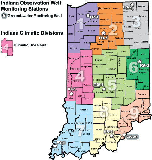
LIST OF SELECTED MONITORING WELLS FOR CLIMATIC DIVISIONS
| Climatic Division | Monitoring Well | Aquifer Type | Well Depth (ft) | Casing Depth (ft) | Hydrologic Condition |
|---|---|---|---|---|---|
| 1 (NW) | LaPorte 9 | Sand | 32 | 27 | Water Table |
| 2 (NC) | Fulton 7 | Sand & gravel | 102 | 96 | Artesian |
| 3 (NW) | LaGrange 2 | Sand & gravel | 86 | 80 | Water Table |
| 4 (WC) | Vigo 7 | Sand & gravel | 70 | 67 | Water Table |
| 5 (C) | Morgan 4 | Sand & gravel | 64 | 60 | Water Table |
| 6 (EC) | Randolph 3 | Silurian limestone | 54 | 33 | Artesian |
| 7 (SW) | Posey 3 | Sand & gravel | 58 | 54 | Artesian |
| 8 (SC) | Harrison 8 | Mississippian limestone | 93 | 54 | Artesian |
| 9 (SE) | Clark 20 | Sand & gravel | 100 | 80 | Artesian |