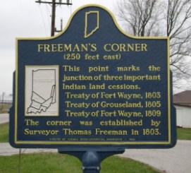
Freeman's Corner (250 feet east)
Location: SR 37, east side of highway north of water works facility, north edge of Orleans. (Orange County, Indiana)
Erected by Indiana Sesquicentennial Commission, 1966
ID# : 59.1966.1
Visit the Indiana History Blog to learn how the survey system defined Indiana's landscape and furthered democracy for white settlers at the expense of the Wyandot, Delaware, Shawnee, Ottawa, Miami, Eel River, Wea, Chippewa, Potawatomi, Kickapoo, Piankashaw, and Kaskaskia people who first made this land home.
Text
This point marks the junction of three important Indian land cessions. Treaty of Fort Wayne, 1803 Treaty of Grouseland, 1805 Treaty of Fort Wayne, 1809 The corner was established by Surveyor Thomas Freeman in 1803. [map]
Keywords
Early Settlement and Exploration, American Indian/Native American