Bilby Steel Tower
Location: Southwest corner of CR 300 N and US 421, Osgood (Ripley County, Indiana)
Installed 2016 Indiana Historical Bureau and Surveyors Historical Society
ID#: 69.2016.1
![]() Visit the Indiana History Blog to learn more about Bilby's life and work.
Visit the Indiana History Blog to learn more about Bilby's life and work.
Text
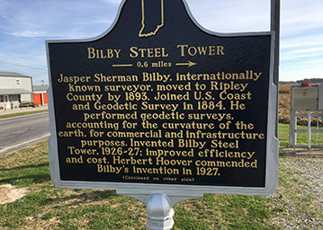
Side One
Jasper Sherman Bilby, internationally known surveyor, moved to Ripley County by 1893. Joined U.S. Coast and Geodetic Survey in 1884. He performed geodetic surveys, accounting for the curvature of the earth, for commercial and infrastructure purposes. Invented Bilby Steel Tower, 1926-27; improved efficiency and cost. Herbert Hoover commended Bilby’s invention in 1927.
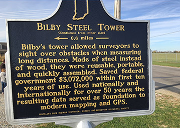
Side Two
Bilby’s tower allowed surveyors to sight over obstacles when measuring long distances. Made of steel instead of wood, they were reusable, portable, and quickly assembled. Saved federal government $3,072,000 within first ten years of use. Used nationally and internationally for over 50 years; the resulting data served as foundation to modern mapping and GPS.
Annotated Text
Side One
Jasper Sherman Bilby, internationally known surveyor,[1] moved to Ripley County by 1893.[2]
Joined U.S. Coast and Geodetic Survey in 1884. He performed geodetic surveys, accounting for the curvature of the earth for commercial and infrastructure purposes.[3] Invented Bilby Steel Tower, 1926-27, which improved efficiency and cost for surveyors.[4] Herbert Hoover commended Bilby’s invention in 1927.[5]
Side Two
Bilby’s tower allowed surveyors to sight over obstacles when measuring long distances.[6] Made of steel instead of wood; were reusable, portable, and quickly assembled.[7] Saved federal government $3,072,000 within first ten years of use.[8] Used nationally and internationally for over 50 years; resulting data foundational to modern mapping and GPS.[9]
[1] “State News,” Indianapolis News, April 17, 1877, 2, IUPUI Digital Collections; 1880 United States Census (Schedule 1), District 140, Harrison Township, Fayette County, Indiana, Roll 276, page 9B, Line 19, June 2, 1880, accessed AncestryLibrary.com; 1910 United States Census (Schedule 1), District 140, Center Township, Ripley County, Indiana, Roll T624_376, page 8A, Lines 34-38, April 20, 1910, accessed AncestryLibrary.com; 1920 United States Census (Schedule 1), District 155, Center Township, Ripley County, Indiana, Roll T625_461, page 10B, Lines 67-71, January 13-14, 1920, accessed AncestryLibrary.com; 1930 United States Census (Schedule 1), District 5, Center Township, Ripley County, Indiana, Roll 623, page 7B, Line 66, April19, 1930, accessed AncestryLibrary.com; US Coast & Geodetic Survey, Who’s Who In the US Coast & Geodetic Survey (Washington DC: Government Printing Office, December 1931), 2, Surveyor’s Historical Society Collection, submitted by applicant; Field Assignments of Jasper S. Bilby, Chief Signalman US Coast and Geodetic Survey, September 1884-December 31, 1927 (Washington DC: Government Printing Office, 1938), Surveyor’s Historical Society Collection, 1, submitted by applicant;
Jasper Sherman Bilby was born in Rush County, Indiana on July 16, 1864 to Jasper N. Bilby and Margaret E. (Hazard) Bilby. An autobiography he wrote for the 1931 Who’s Who in the US Coast & Geodetic Survey, alongside a 1938 Field Assignments report from the, corroborates his birth in Rush county. (A genealogist-generated Ancestry Library family tree places his birth in Fayette County, but the researchers provided no primary sources for their claim.) He received no formal education after the eighth grade. The earliest Census record available is 1880, where he is listed with his mother at age 15 and worked on a farm in Fayette County. Before he became a surveyor at the age of 20, he served as a “foreman” of a stock farm in Illinois.
[2] Grantor’s Deed, “Stephen Bruce, Jr., Grantor, and Cox and Bilby, Grantees, of Land in Section 2, Township 7, Range 10, Batesville, Indiana,” November 6, 1893, Recorded November 9, 1893, Ripley County Index to Deeds, Number 9 (Grantor), 1888-1898, ISL Microfilm Collection; Grantor’s Deed, “David N. Overturf, Grantor, and Cox and Bilby, Grantees, of Land in Section 3, Township 7, Range 10, Batesville, Indiana,” January 31, 1894, Recorded February 1, 1894, Ripley County Index to Deeds, Number 9 (Grantor), 1888-1898, ISL Microfilm Collection; “Real Estate Transfers,” Osgood Journal (Indiana), March 12, 1896, 5, accessed Newspaper Archive; “Real Estate Transfers,” Batesville Journal (Indiana), December 4, 1902, 5, accessed Newspaper Archive; “Transfer Notes,” Batesville Tribune (Indiana), June 8, 1910, 1, accessed Newspaper Archive; Atlas and Plat Book of Ripley County and Part of Franklin County, Indiana (Batesville, Indiana: Herald Publishing Company, 1921), 27, Ball State University Digital Media Repository; The Business and Professional Women of Osgood, Verseilles, Milan and Holton, ed., History of Ripley County, Indiana (Batavia, Ohio: Clermont Publishing Company, 1968), 48, Indiana State Library.
In 1893-94, Bilby (with either his wife or Father-In-Law; it is listed as “Cox and Bilby”) leased land in Ripley County for his family to live on while he was away on surveying work, according to Ripley County deed index books. The years 1888-1892, which are also listed in this volume of the deed index, show no listing of Bilby. The Osgood Journal notes that Bilby then purchased land in Holton, Ripley County from a Martha B. Cox for $1000 in 1896. In 1902, according to the Batesville Tribune, Bilby purchased land in Osgood, Ripley County, for $1,500. He resided at this address until at most 1921, when a Ripley County Atlas & Plat Book records his residence in Center Township, Osgood, in Ripley County. While the primary sources may not place his residence in Ripley County as early as the county history (they list his entry as 1890), it is clear the Bilby did move to Ripley County as early as 1893. Further research is needed in the Deed Books to corroborate the Ripley County History’s claim.
[3] An Act to Provide for Surveying the Coasts of the United States, 1807, Public Law 413-14, 9th Congress, 2nd Session, accessed NOAA.org; 1910 United States Census, accessed AncestryLibrary.com; 1920 United States Census, accessed AncestryLibrary.com; “Holton,” Connersville Daily News (Indiana), January 1, 1891, 3, accessed Newspaper Archive; Ripley Journal (Osgood, Indiana), August 27, 1891, 1, accessed Newspaper Archive; Connersville Courier (Indiana), May 23, 1901, 1, accessed Newspaper Archive; “Establishing Triangulation Towers,” Rice Belt Journal (Welsh, Calcasieu Parish, Louisiana), October 28, 1904, 2, accessed Chronicling America; “Commerce,” Brownsville Daily Herald (Texas), November 23, 1905, 4, Chronicling America; Brownsville Daily Herald (Texas), November 24, 1905, 4, accessed Chronicling America; ”Personals,” Brownsville Daily Herald (Texas), April 11, 1906, 4, accessed Chronicling America; “Geodetic Survey Party Working Near Osceola,” Blytheville Courier News (Arkansas), August 23, 1929, 3, accessed Newspaper Archive; ”Geodetic Work,” Coast Survey Bulletin (Washington DC), December 1915, no. 7, 1, accessed Google Books; United States Coast & Geodetic Survey, Annual Report of the Superintendent, United States Coast and Geodetic Survey to the Secretary of Commerce for the Fiscal Year Ended June 30, 1915 (Washington DC: Government Printing Office, 1915), 79, accessed NOAA.gov; Clarence H. Swick, Descriptions of Triangulation Stations in Georgia (Washington DC: Government Printing Office, 1917), 40, accessed Google Books; H.G. Ayers, Precise Leveling in Texas (Washington DC: Government Printing Office, 1922), 1, 59-61, accessed Google Books; Charles A. Mourhess and Walter D. Sutcliffe, Precise Traverse, Racine Wis., to Vandalia, Ill. (Washington DC: Government Printing Office, 1922), 20-46, accessed Google Books, Donald Edward Keyhoe, “Blazing Trails for the Map Makers,” Popular Mechanics 46, no. 1 (July 1926): 19-23, accessed Google Books; US Coast & Geodetic Survey, Who’s Who In the US Coast & Geodetic Survey, 2; Raymond Stanton Patton, “Recent Advancements in Coast and Geodetic Survey Methods,” Annals of the Association of American Geographers 22, no. 1 (March 1932): 5, accessed JSTOR; National Oceanic and Atmospheric Administration, Geodesy for the Layman, 5th Edition (Washington, DC: US Department of Commerce, 1983), 1-6, accessed NOAA.org; “History Overview,” National Geodetic Survey, last updated 2015, accessed NOAA.gov; “What We Do,” National Geodetic Survey, last updated 2015, accessed NOAA.gov; Charles A. Mourhees and Jasper Sherman Bilby, Precise Traverse and Triangulation in Indiana (Washington DC: Government Printing Office, 1922): 3-103, submitted by applicant; Jasper Sherman Bilby, Reconnaissance and Signal Building (Washington DC: Government Printing Office, 1923): 1-77, submitted by applicant; Jasper Sherman Bilby, Bilby Steel Tower for Triangulation (Washington DC: Government Printing Office, 1929): 1-23, submitted by applicant; Jasper Sherman Bilby, Bilby Steel Tower for Triangulation [Revised Edition] (Washington DC: Government Printing Office, 1940): 1-27, accessed Indiana University-Purdue University Indianapolis Library; Jasper Sherman Bilby, Signal Building (Washington DC: Government Printing Office, 1943): 1-43, submitted by applicant.
On February 10, 1807, Congress established the United States Survey of the Coast. It was originally under the purview of the Treasury Department, but later subsumed under the US Department of Commerce in 1878 and renamed the United States Coast & Geodetic Survey (US C&GS). Today, it is under the umbrella of the National Oceanic and Atmospheric Administration (NOAA) and called the National Geodetic Survey (NGS). Geodetic surveying is the geographical analysis of an area of land or bodies of water accounting for the shape and curvature of the Earth. According to the NGS official website, the National Geodetic Survey, from its inception in 1807, has ensured accurate data for government and commercial purposes, such as “mapping and charting, navigation, flood risk determination, transportation, [and] land use and ecosystem management.” Additionally, the National Geodetic Survey’s work provides “authoritative spatial data, models, and tools are vital for the protection and management of natural and manmade resources and support the economic prosperity and environmental health of the Nation.”
Bilby joined the United States Coast & Geodetic Survey in September of 1884 and conducted his first survey work in Illinois along the 39th parallel. According to surveyor Raymond Stanton Patton, the 39th parallel was a line of latitude that spanned from Cape May, New Jersey to Point Area, California, and was the “first great piece of geodetic work accomplished by the Survey….”
Jasper Sherman Bilby’s official position within the US C&GS for most of his career was that of “signalman.” A signalman uses flags or signal lights to indicate points within a geometric calculation between two survey points, usually between a point on shore and a point within a body of water. This practice ensures that those making the calculations on shore accurately represent the point in water.
Bilby’s surveying work took him all around the United States, from Illinois to California. He spent a considerable time surveying areas in the state of Texas during the 1900s and 1910s. He traveled 511,400 miles during his years in the US C&GS. Newspapers throughout the country recorded his cross-country traveling for the US C&GS, notably his work in states like Louisiana, Arkansas, and Texas. Department of Commerce publications also chronicle his time in Wisconsin, Illinois, and Georgia, detailing his work in specific counties. In 1920, Bilby and his team surveyed the majority of Wisconsin and Illinois, providing exact coordinates for most regions adjacent to water. In these surveys, Bilby used the Traverse method of surveying, which is less accurate but quicker to calculate than Triangulation. (The traverse method uses pointed lines for measurements while triangulation uses angular measurements based on triangles.) Bilby and his team completed surveys within the Rio Grande valley in 1917, specifically from Harlington to Dryden. His efforts in the eastern area of the Rio Grande ensured more accurate measurements, adding to the US C&GS’s triangulation of the American west.
A 1926 article published in Popular Mechanics provides some of Bilby’s own words on his job, especially its difficulty before his invention and some personal stories. One of Bilby’s tasks within the US C&GS was reconnaissance, which is the practice of marking triangulation stations before the main survey party arrives. This cuts down on their work and ensures accuracy in their measurements. He told the magazine about the harsh weather and loneliness that often accompanies a surveyor’s life:
Especially…when the wind is howling through the trees, and the rain is pattering down on the tent, and you know there’s little change of anyone dropping by.
Nevertheless, he enjoyed his work and appreciated how radio was improving the public’s knowledge of the work the US C&GS does. Bilby notes:
Radio has made the coast and geodetic survey known more than it used to be. A few years ago people were always asking what the name meant, but now I often find they know us pretty well, from talks they’ve heard on the air. One lecture on mountain building which was broadcast from Washington was the means of getting me a fine dinner. I had stopped at a farmhouse to make inquiries and the farmer noticed my ‘geodetic’ tag. He mentioned this talk he’d heard, and when I said it must have been given by the chief of my division, Major Bowie, he became so interested that he made me stay to dinner and answer his questions. However, that wasn’t unwelcome after eating my own cooking for so long.
This story was published a year before the first usage of the Bilby Steel Tower, when wooden towers were still standard equipment.
Even before the invention of the Bilby Tower, he found ways within the US C&GS to innovate. Over a decade before, he supported use of newly-adopted motor trucks. In the December 1915 issue of the Coast Survey Bulletin, Bilby noted their effectiveness and efficiency in the 1915 surveying season, the first time they were used. He wrote that it “seems reasonably certain that the motor truck can be used successfully in any part of the country.” The 1915 Annual Report of the US C&GS echoed Bilby’s remarks: “The automobile truck proved to be an efficient method of transportation as it considerably decreased the unit cost of the work from what it would have been with horses and wagons for moving the party with its outfit and supplies.” Years later, trucks became a vital part for the usage of the Bilby Towers. The manual on Bilby Towers provided exact measurements for a trailer truck for triangulation parties and noted their indispensability.
He wrote several government manuals on the theory and practice of geodetic surveying. His most famous and influential work was the manual on his invention, the Bilby Steel Tower. Bilby Steel Tower for Triangulation (1929) covered every aspect of his invention, from concept and construction to its usage and transport. It stayed in publication through two editions. Other manuals include Precise Traverse and Triangulation in Indiana (1922), Reconnaissance and Signal Building (1923), and Signal Building (1943).
[4] United States Coast & Geodetic Survey, Annual Report of the Superintendent, United States Coast and Geodetic Survey to the Secretary of Commerce for the Fiscal Year Ended June 30, 1915, 79, accessed NOAA.gov; Coast Survey Bulletin (Washington DC), December 1915, no. 7, 1, Google Books; Field Assignments of Jasper S. Bilby, Chief Signalman U.S. Coast and Geodetic Survey, September 1884-December 31, 1927 (Washington DC, Government Printing Office, 1938), Surveyor’s Historical Society Collection, submitted by applicant; Bilby, Bilby Steel Tower for Triangulation, 1-9, submitted by applicant; John Durham, “Nation’s Vast Geodetic Survey to Give New Accuracy in Maps,” New York Times, September 21, 1930, x14, ProQuest/Historic New York Times; E. Lester Jones to J.S. Bilby, September 5, 1927, US Department of Commerce, US Coast & Geodetic Survey, submitted by applicant; Wilcove, “Jasper Bilby’s Brainchild,” 27, NOAA.gov; John Noble Wilford, The Mapmakers [Revised Edition] (New York, Alfred A. Knopf, 2000), 356-359, accessed Google Books.
The Bilby Tower, as described by historian John Noble Wilford, was used for horizontal-control surveys (measuring latitude and longitude) and allowed surveyors to see over hills, trees, or other impediments to make their measurements more accurate.
According to US C&GS documents on his field assignments, Bilby began his designs on the tower as early as December 1926. He then took his early design plans to the Aeromotor Factory in Chicago to make a prototype. Once the prototype proved successful, twelve complete towers were manufactured by the same company and were first tested on assignment in Albert Lee, Minnesota with positive results.
In terms of design, the Bilby Tower was actually comprised of two independent towers. An inner tower carried the intricate instruments for survey calculations and the outer tower supported the surveyors who made the measurements. These towers never connected, so that the vibrations of either one did not disturb the survey calculations. In 1927, it was named the “Bilby Steel Tower” by Colonel Lester E. Jones, then director of the US C&GS.
For information on how the towers increased efficiency and decreased cost, see footnote seven.
[5] “Commerce,” Washington Post, March 28, 1915, 3, accessed Fold3 by Ancestry.com; “Changes in Civil Service,” Evening Star (Washington, DC), July 9, 1915, 8, accessed Chronicling America; Adrienne Ervin, “Meet Jasper Sherman Bilby,” National Republic (Washington, DC), July 1928, 36, submitted by applicant; “45 Years in Uncle Sam’s Service,” Lake County Times (Hammond, IN), May 9, 1929, 17, accessed Newspaper Archive; “Hoover Exempts 22 Under New Act,” Evening Star (Washington, DC), July 30, 1932, 1, submitted by applicant; Herbert Hoover to Jasper S. Bilby, September 19, 1927, US Department of Commerce, US Coast & Geodetic Survey, submitted by applicant; Edward J. Gardner to Jasper S. Bilby, March 25, 1930, Appointment Division, US Department of Commerce, submitted by applicant;.
In a 1927 commendation letter, Secretary of Commerce (and future President) Herbert Hoover commended Bilby’s invention for its cost and time efficiency and cited the surveyor’s service as essential to the United States government.
I have just learned, upon my return to Washington, of the excellent results which the Coast and Geodetic Survey is getting in its triangulation from the steel towers which you designed.
The accelerated progress of the work, accompanied by a reduction in its cost, is highly gratifying to me and justify the commendation which this letter conveys.
However, Hoover’s letter was not the only special commendations he received while in the US C&GS. He earned financial promotions through 1915- 1916 and in 1930, the position of “Chief Signalman” was created for him. Understanding Bilby’s work as essential to the US C&GS, President Hoover used an executive order in 1932 to waive the mandatory federal retirement age.
Newspapers also commended his service and vitality to the US C&GS. A 1928 piece in the National Republic reported: “Every class of work in which the U.S. Coast and Geodetic Survey engages has benefitted by his keenness of mind.” He reached 45 years of service in 1929 and the Lake County Times published a piece celebrating his invention of the Bilby Steel Tower and his “international recognition” in the field of geodesy.
[6] Jasper Sherman Bilby, Bilby Steel Tower for Triangulation, Revised Edition (Washington, DC: United States Government Printing Office, 1940, 1; Adrienne Irvin, “Bilby Tower for Government Surveys,” Military Engineer 19, no. 107 (September-October 1927): 400.
In his manual, Bilby Steel Tower for Triangulation, Bilby detailed this problem of visibility:
In many regions it is not possible to select stations for a scheme of triangulation and have the stations intervisible from the ground, as trees, buildings, and other objects obstruct the line of vision between adjacent points. On geodetic surveys, covering wide expanses of territory, the curvature of the earth must also be taken into account. Towers are, therefore, necessary to elevate above intervening obstructions the observer and his instrument at one station and the signal lamp or object on which he makes his observations at the distant station.
Additionally, Adrienne Irvin of the US C&GS explained this problem in a 1927 article for the Military Engineer:
Rolling terrain, trees, and buildings all obstruct the line of vision between two points whose latitudes and longitudes it is required to determine and, where high hills are absent, towers are necessary to elevate above intervening obstructions the observer and his instrument at one station and the signal lamp, on which he makes his observations, at the distant station.
[7] H.G. Avers, “Progress of the Geodetic Work of the United States Coast and Geodetic Survey,” in Bulletin of the National Research Council: Transactions of the American Geophysical Union, Ninth Annual Meeting, April 26 and 27, 1928, Washington, D.C., no. 68 (February, 1929) (Washington, DC: National Research Council of the National Academy of Sciences): 39, Google Books; US Coast & Geodetic Survey, Field Assignments of Jasper S. Bilby, Chief Signalman U.S. Coast and Geodetic Survey, September 1884-December 31, 1927, 7-8, submitted by applicant.
In a report to the American Geophysical Union in 1928, H.G. Avers noted that Bilby Towers were first used in Minnesota during the 1927 survey season with considerable success. The report additionally detailed the reasoning behind Bilby’s invention:
The almost prohibitive cost of lumber in recent years and the fact that a wooden tower can be used at only one station, since it is impracticable to dismantle it and use the lumber again, led Mr. J.S. Bilby, Signalman and Chief of Party of the U.S. Coast and Geodetic Survey, to design a steel tower.
Additionally, the steel towers took only five to six hours to build while wooden towers took five to six days. A steel tower can be disassembled within three hours (wooden towers are not reusable).
[8] US Coast & Geodetic Survey, Annual Report of the Superintendent, United States Coast and Geodetic Survey to the Secretary of Commerce for the Fiscal Year Ended June 30, 1928 (Washington, DC: Government Printing Office, 1928), 24, NOAA.gov; US Coast & Geodetic Survey, Designs in 1927 by Chief Signalman J.S. Bilby, US Coast & Geodetic Survey (Washington DC: US Department of Commerce, 1937), 1, submitted by applicant; US Coast & Geodetic Survey, Field Assignments of Jasper S. Bilby, Chief Signalman U.S. Coast and Geodetic Survey, September 1884-December 31, 1927, submitted by applicant.
The amount saved by the Federal Government comes from the itemized cost listing of both wooden and steel towers from 1927-1937 by the US C&GS field assignment reports. The 1928 US C&GS annual report explained how the implementation of Bilby Towers cut unit costs down by nearly half, much more than the projected 25-35% savings. It also increased their surveying progress to over “150 miles per month.”
[9] R.S. Patton to Director General, Military Cartographic Institute, Brussels, Belgium, November 9, 1929, US Coast & Geodetic Survey, US Department of Commerce, submitted by applicant; R.S. Patton to General A. Bellot, January 7, 1931, US Coast & Geodetic Survey, US Department of Commerce, submitted by applicant; N. E. Nörlund to Dr. W. Bowie, January 7, 1931, US Coast & Geodetic Survey, US Department of Commerce, submitted by applicant; R.S. Patton to John Percy Camm, August 13, 1933, US Coast & Geodetic Survey, US Department of Commerce, submitted by applicant; R.S. Patton to Jasper S. Bilby, September 28, 1937, US Coast & Geodetic Survey, US Department of Commerce, submitted by applicant; Daniel C. Roper to Jasper S. Bilby, January 17, 1938, US Department of Commerce, submitted by applicant; Adrienne Ervin, “Meet Jasper Sherman Bilby,” National Republic (Washington, DC), July 1928, 36, submitted by applicant; US Coast & Geodetic Survey, Field Engineers Bulletin, US Coast & Geodetic Survey, no. 12 (December 1938), 207, accessed Hydrologic Society of America Educational Archive; US Coast & Geodetic Survey, Field Engineers Bulletin, US Coast & Geodetic Survey, no. 11 (December 1937), 28, accessed Hydrologic Society of America Educational Archive; Bilby, Bilby Steel Tower for Triangulation [Revised Edition], 1-27; “Jasper Bilby, 86, Dies Monday Evening,” Osgood Journal (Indiana), July 21, 1949, 1, ISL Newspaper Microfilm Collection; “Death Certificate: Jasper S. Bilby,” in Washington, Select Death Certificates, 1907-1950 (Salt Lake City, UT: Ancestry.com Operations, Inc., 2014, Ancestry.com); “Bilby Towers,” NOAA: Celebrating 200 Years of Science, Service, and Stewardship, last updated July 19, 2012, accessed NOAA.gov; C. Barton Crattie, “A Journey’s End,” American Surveyor (January 2014): 2-10, accessed amerisurv.com; C. Barton Crattie, “Mr. Bilby’s Elegant Assembly,” American Surveyor 8, no.4 (May 2011): 2-7, accessed amerisurv.com National Geodetic Survey, “What We Do,” NOAA, last updated 2015, accessed NOAA.gov; National Geodetic Survey, “NOAA Manages the National Spatial Reference System,” NOAA, last updated 2015, accessed NOAA.gov.
His invention was widely used and garnered international recognition. In a July, 1928 article in the National Republic, it was noted that “his name is known throughout the world as that of the designer of the Bilby steel tower….”
Within a few years of its invention, the Bilby Steel Tower was used in nations such as France, Australia, Belgium, and Denmark. In particular, Major M. Hotine, Royal Engineer of the Ordinance Survey Office in Southampton, England, wrote of his satisfaction with the Bilby Steel Tower in the December 1938 issue of the US C&GS Field Engineers Bulletin:
We have just completed among other work this season, the primary observation for our new triangulation in the Eastern Counties of England. The country here is so flat and enclosed that we had to use Bilby Steel Towers at 34 of the main Stations [sic], to say nothing of several secondary stations surrounding such Steel Tower States, we thought it would be advisable to observe at the same time as the primary work. You may be interested to know that these admirable Steel Towers were entirely satisfactory; and that we were very deeply impressed with the conception, design, and construction of these Towers.
Bilby retired from the US C&GS in 1937. His final assignment was at a triangulation station in Hunt City, Jasper County, Illinois, completing his 53 year career exactly where it began on the 39th parallel. In the December 1937 issue of the US C&GS Field Survey Bulletin, Bilby’s career and influence is noted in this passage:
The length of Mr. Bilby’s service covers half the entire period of the Coast and Geodetic Survey’s activities….He has witnessed the transition in transportation equipment from the ox carts used on the Mexican Boundary surveys, when twenty miles was a hard [emphasis in original] day’s ride, to the high speed, air cushioned, automobile truck which now may carry our survey parties comfortably over 400 miles of well-paved roads in the same length of time; he has seen base measuring apparatus change from base bars to invar tapes, wooden signal towers, which could be used but once, give way to portable steel towers of his own design; (the Bilby Steel tower is named after him); wages changed from $20 per month, with board, to many times that amount.
His 1927 manual for the Bilby Tower was revised for surveyors in 1940 and his work continued to influence the trade well into the 1980s. The last Bilby Tower was erected in 1984, in Connecticut. A complete survey tower, originally constructed on an island south of New Orleans, Louisiana called Couba in 1972, was restored and moved to the town park in Bilby’s hometown of Osgood, Ripley County, Indiana in 2014.
Bilby died on July 18, 1949 in Batesville, Indiana. He was buried in Washington Park Cemetery in Indianapolis. His long career and advancements in geodetic surveying technology, particularly on the 39th parallel, ensured the completion and accuracy of the National Spatial Reference System (NSRP), a first-order triangulation network of the United States.
The NSRP, according to the National Geodetic Survey, is a “consistent coordinate system that defines latitude, longitude, height, scale, gravity, and orientation throughout the United States.” This system’s continued use ensures accurate information for the United State’s Global Navigation Satellite System (GNSS), known domestically as the Global Positioning System (GPS).
Keywords
Science, Medicine, & Invention; Government Institution