Ohio River Levee
Location: Eastern portion of Dress Plaza along the Ohio River in downtown Evansville, near the intersection of Walnut Street & Riverside Drive. (Vanderburgh County, Indiana)
Installed: 2003 Indiana Historical Bureau, Vanderburgh County Historical Society, and Evansville-Vanderburgh Levee Authority District
ID# : 82.2003.1
Text
Side one:
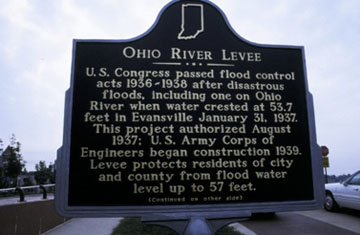
U.S. Congress passed flood control acts 1936-1938 after disastrous floods, including one on Ohio River when water crested at 53.7 feet in Evansville January 31, 1937. This project authorized August 1937; U.S. Army Corps of Engineers began construction 1939. Levee protects residents of city and county from flood water level up to 57 feet.
Side two:
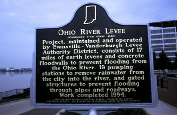
Project, maintained and operated by Evansville-Vanderburgh Levee Authority District, consists of 17 miles of earth levees and concrete floodwalls to prevent flooding from the Ohio River, 19 pumping stations to remove rainwater from the city into the river, and gated structures to prevent flooding through pipes and roadways. Work completed 1994.
Keywords
Nature and Natural Disasters , Government Institutions
Annotated Text
Side one:
U.S. Congress passed flood control acts 1936-1938 after disastrous floods, including one on Ohio River when water crested at 53.7 feet in Evansville January 31, 1937.(1) This project authorized August 1937; U.S. Army Corps of Engineers began construction 1939. Levee protects residents of city and county from flood water level up to 57 feet.(2)
Side two:
Project, maintained and operated by Evansville-Vanderburgh Levee Authority District, consists of 17 miles of earth levees and concrete floodwalls to prevent flooding from the Ohio River, 19 pumping stations to remove rainwater from the city into the river, and gated structures to prevent flooding through pipes and roadways.(3) Work completed 1994.(4)
Notes:
(1) U.S Congress, Flood Control Acts of 1936, 1937, 1938; Evansville Courier, January 28, 30, February 1, 1937; Comprehensive Flood Control Plan for Ohio and Lower Mississippi Rivers, Hearings …Levees and Flood Walls, Ohio River Basin, June 1937, pp. 8, 14, [Reservoir Plan], 29, 48, 50, 76, 78, 88; Howard Rosen and Martin Reuss, The Flood Control Challenge, 22, 28-33.
(2) Comprehensive Flood Control Plan for Ohio and Lower Mississippi Rivers (Washington, D.C., 1937), pp. 8, 14, 48, 89; Operation and Maintenance Manual Local Flood Protection Project Revised 1993, Section 2, Project Description, Evansville-Vanderburgh Levee Authority District, City of Evansville; City of Evansville, Levee Authority Web site accessed January 25, 2001; Chuck Parrish, U.S. Army Corps of Engineers, District Historian, Louisville [Ky.], Public Affairs Office, "EVANSVILLE, INDIANA, Condition of Improvement, 30 September 1995"; Evansville Courier, August 19, 1991, July 23, 1993, January 19, 1997; Parrish, e-mails, November 14, 20, 21, 2002; Parrish telephone call, November 21, 2002.
(3) Operation and Maintenance Manual; City of Evansville, Levee Authority Web site; Parrish, "EVANSVILLE, INDIANA"; Evansville Courier, August 19, 1991; Parrish, e-mail, November 14, 2002.
(4) Parrish, "EVANSVILLE, INDIANA."