Location: Fairbanks Park, First & Oak Streets, Terre Haute. (Vigo County, Indiana)
Installed: 2004 Indiana Historical Bureau and Native American Foundation of Western Indiana
ID# : 84.2004.1
Text
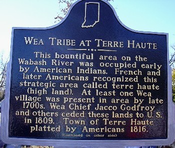
Side one:
This bountiful area on the Wabash River was occupied early by American Indians. French and later Americans recognized this strategic area called terre haute (high land). At least one Wea village was present in area by late 1700s. Wea Chief Jacco Godfroy and others ceded these lands to U.S. in 1809. Town of Terre Haute platted by Americans 1816.
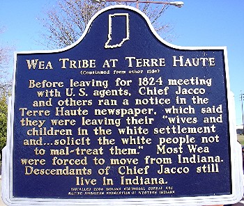
Side two:
Before leaving for 1824 meeting with U.S. agents, Chief Jacco and others ran a notice in the Terre Haute newspaper, which said they were leaving their "wives and children in the white settlement and . . . solicit the white people not to mal-treat them." Most Wea were forced to move from Indiana. Descendants of Chief Jacco still live in Indiana.
Keywords
American Indian/Native American
Annotated Text
This bountiful area on the Wabash River was occupied early by American Indians.(2) French and later Americans recognized this strategic area called terre haute (high land).(3) At least one Wea village was present in area by late 1700s.(4) Wea Chief Jacco Godfroy and others ceded these lands to U.S. in 1809.(5) Town of Terre Haute platted by Americans 1816.(6)
Before leaving for 1824 meeting with U.S. agents, (7) Chief Jacco and others ran a notice in the Terre Haute newspaper, which said they were leaving their "wives and children in the white settlement and . . . solicit the white people not to mal-treat them."(8) Most Wea were forced to move from Indiana.(9) Descendants of Chief Jacco still live in Indiana.(10)
Notes:
(1) The Wea Tribe is considered to be part of the Miami Nation. Proving the specific Wea presence in Terre Haute at a specific time is complicated by the lack of tribal distinction in the available primary sources created by the French, British, and Americans at various points in time. References in early primary sources most often refer only to the Wabash Indians or the Miamis: there could or could not be Weas included.
Following are some references in primary sources and conclusions of scholars who have worked deeply in available primary sources.
Late eighteenth century, there were six Miami-speaking groups. Three of the groups, the Wea, Piankashaw, and Atchatchakangouen later became tribes. Stewart Rafert, The Miami Indians of Indiana: A Persistent People, 1654-1994 (Indianapolis, 1996), 7. See also Erminie Wheeler-Voegelin, Emily J. Blasingham, and Dorothy R. Libby, Miami, Wea, and Eel-River Indians of Southern Indiana: An Anthropological Report on the Miami, Wea, and Eel-River Indians. . . , American Indian ethnohistory: North central and northeastern Indians, Vol 3, (New York, 1974), 14-18.
The Miami-speaking groups moved southeastward to settle on the Wabash River. The Piankashaw settled near Vincennes, the Wea near Lafayette, and the Atchatchakangouen (or Crane band Miami) near Ft. Wayne. Rafert, 27.
Voegelin, et al., Anthropological Report, 70, 137, states that prior to the early 1790s, Wabash Indians included Wea, Eel River, Kickapoo, Mascouten, and Piankashaw; by 1795 one group of Potawatomis was also included as Wabash Indians.
With reference to an 1801 document, Charles B. Lasselle, "The Old Indian Traders of Indiana, " Indiana Magazine of History, Vol. 2 (March 1906), 11, notes: "This Terrehaute was inhabited by the Weah branch of the Miamis, and was situated near the present town of Terre Haute, which was named after it."
1805, August 21, Treaty at Grouseland ”Delawares, Potawatomis, Miamis, Eel Rivers and Weas. Delawares ceded land from White River south to Ohio River and Clark's Grant; treaty also establishes Miamis, Eel River, and Weas were and still considered themselves one nation so that no one tribe could dispose of land without the consent of the others. Charles J. Kappler, comp., Indian Affairs: Laws and Treaties, 7 Vols. (Washington, 1904), 2:80-82. Accessed at: http://digital.library.okstate.edu/kappler/Vol2/treaties/de10080.htm. All additional references to this source are available at this Web site.
(2) According to Erminie W. Voegelin, "Indiana . . . is rich in archaeological remains which indicate that in prehistoric times the Ohio Valley region supported a large native population." Erminie Wheeler-Voegelin, "Indians of Indiana, " Proceedings of the Indiana Academy of Science, Vol. 50 (1941), 27. See also Vernon R. Helmen, Archaeological Survey of Vigo County (Indianapolis, 1952).
In John D. Barnhart and Dorothy L. Riker, Indiana to 1816, The Colonial Period (Indianapolis, 1971), pp. 65-66, the authors summarize information about the historic period: "In the eighteenth century both Indiana and Ohio became refuge areas for a large number of Indian tribes or segments of tribal groups. . . . the Kickapoo, Potawatomi, Miami, Piankashaw, Wea, and Hurons, were from the Great Lakes area.
"Of the tribes which moved into Indiana, the Miami and two closely related groups, the Wea and the Piankashaw, occupy a foremost place. . . .
"Some of the Wea had shifted to the Wabash River in the area of the present Tippecanoe County, Indiana, by 1700; at that time another band was still at the site of Chicago but probably joined the rest of the tribe on the Wabash shortly thereafter. The Piankashaw had a village farther down the Wabash at the mouth of the Vermilion River; by 1750 a branch of the Kickapoo had also settled on the Vermilion and Wabash rivers."
A sampling of primary sources focusing on the Wea follows.
1698 “ 1702, Wea at Chicago have been settled there for ten or 12 years. "Memoir of De Gannes Concerning the Illinois Country, " The French Foundations: 1680-1693, ed., Theodore C. Pease and Raymond C. Werner, Collections of the Illinois State Historical Society, Vol. 23 (Springfield, 1934), 392, accessed at Glenn Black Laboratory of Archaeology, The Ohio Valley-Great Lakes Ethnohistory Archives: The Miami Collection, online at: www.gbl.indiana.edu/archives/menu.html.
1701, Charlevoix found Weas at Chicago. Pierre-Francois-Xavier de Charlevoix, History and General Description of New France, 6 Vols., trans. John Gilmary Shea (New York, 1902), 5:142, accessed at Glenn Black Laboratory of Archaeology, The Ohio Valley-Great Lakes Ethnohistory Archives: The Miami Collection, online at: www.gbl.indiana.edu/archives/menu.html.
As early as 1708, Wea Indians were living on the Wabash River. Voegelin, Anthropological Report, 14, cites Frances Krauskopf, "The French in Indiana, 1700-1760: A Political History" (Ph.D. dissertation, Indiana University, 1953), 32, Indiana Division, Indiana State Library, microfilm; and, Letter from Sieur D'Aigremont, November 14, 1708, Michigan Historical Collections, Vol. 33 (Lansing, 1903), 441. Both can be accessed at Glenn Black Laboratory of Archaeology, The Ohio Valley-Great Lakes Ethnohistory Archives: The Miami Collection, online at: www.gbl.indiana.edu/archives/menu.html.
Voegelin, p. 141, adds "that the region near the mouth of the Wea Creek, opposite the French fort of Ouiatanon on the middle Wabash, was for a long period of time (1717-1790) the center for Wea summer village life. At this spot on the Wabash all of the Weas had their summer villages and their extensive cornfields for at least 72 years."
(3) Indiana to 1816, pp. 57-93, provides a good overview of the white incursion into the area that became Indiana, starting with a chapter on "French Exploration and Occupation."
A sampling of primary sources focusing on interaction between whites and Indians at Terre Haute follows.
On September 12, 1746, supplies were given to Indians at Ouiatenon by Michael Gamelin (French trader) including Le Brave, Mascouten chief at Terre Haute. There is no mention of Wea at Terre Haute. "List of Supplies. . .1747, " Michael Gamelin, Ouiatenon Documents, trans. and ed., Frances Krauskopf, Indiana Historical Society Publications, Vol. 18 (Indianapolis, 1955), 198.
April 28, 1752, Ligneris to Vaudreuil: Letter states that Kickapoo live at Terre Haute. There is no mention of Wea. Letter, de Ligneris to Vaudreuil, April 28, 1752, Illinois on the Eve of the Seven Years' War, 1747-1755, eds. Theodore Calvin Pease and Ernestine Jenison, Collections of the Illinois State Historical Library, vol. 29 (Springfield, 1940), 415-16, accessed June 9, 2004 at Glenn Black Laboratory of Archaeology, The Ohio Valley-Great Lakes Ethnohistory Archives: The Miami Collection, online at: www.gbl.indiana.edu/archives/menu.html.
1757 Memoir of Bougainville (came to Canada in 1756 as aide-de-camp to French General Louis-Joseph de Montcalm). Lists French posts on the Wabash: Miamis, Ouyatanons, Vincennes; he does not mention Terre Haute. Memoir of Bougainville, 1757, Collections of the Historical Society of Wisconsin, vol. 18, (Madison, ? n.d.), 175, accessed at Glenn Black Laboratory of Archaeology, The Ohio Valley-Great Lakes Ethnohistory Archives: The Miami Collection, online at: www.gbl.indiana.edu/archives/menu.html.
1763 Aubry's (French commandant at Ft. Chartres) Account of the Illinois Country. Describes Wabash River Valley: Fort at Vincennes is last Post in Louisiana Department. Indians living near are Piankashaws. Sixty leagues from Vincennes is Ouiatanons and sixty more up Wabash to Miamis. He does not mention Terre Haute. "Aubry's Account of the Illinois Country, 1763, " The Critical Period, 1763-1765, eds. Clarence W. Alvord and Clarence E. Carter, Collections of the Illinois State Historical Library, Vol. 10 (Springfield, 1915), 3, accessed June 9, 2004 at Glenn Black Laboratory of Archaeology, The Ohio Valley-Great Lakes Ethnohistory Archives: The Miami Collection, online at: www.gbl.indiana.edu/archives/menu.html.
1765 George Croghan (British Indian agent) left Post Vincennes for Ouiatanon; passed through Piankashaw hunting grounds along Wabash River to the Vermillion River where there was a Piankashaw village. No mention of Wea until Ouiatanon. George Croghan, "A selection of George Croghan's letters and journals. . . 1765, " in Reuben Gold Thwaites, Early Western Travels, Vol. 1 (Cleveland, 1904), 142-43, accessed March 11, 2004 at American Notes: Travels in America, 1750-1920 at: http://memory.loc.gov/.
Following the Treaty of Paris in 1783 with Great Britain, the U.S. government and its agents controlled land to the Mississippi River, and they set out to deal with the American Indians who occupied the land.
Some pertinent references to the Wabash River and Terre Haute area follow.
1787, July 28 ”8 Piankashaw Indians arrive at Post Vincennes "from the Terre haut up the Wabash." Harmer to Knox, August 7, 1787, Outpost on the Wabash, 1787-1791, ed., Gayle Thornbrough, Indiana Historical Society Publications, Vol. 19 (Indianapolis, 1957), 37.
1788 ”1, 000 American Indians along the Wabash River and its branches included Kickapoos, Piankashaws, Mascoutens and Weas. "A List of the Different Nations and Tribes of Indians . . . with the Number of their Fighting Men. . . . In the year 1778, " Parkman Papers, Massachusetts Historical Society, 454-55, accessed March 2, 2004 at Glenn Black Laboratory of Archaeology, The Ohio Valley-Great Lakes Ethnohistory Archives: The Miami Collection, online at: www.gbl.indiana.edu/archives/menu.html
1788 ”1800 American Indians on the Wabash includes Piankashaws, Kickapoos, Mascoutens, Vermillions, Weas. "Census, " Samuel P. Hildreth, Pioneer History: being an account of the first examinations of the Ohio Valley. . . . (Cincinnati, 1848), 129, accessed March 2, 2004 at Glenn Black Laboratory of Archaeology, The Ohio Valley-Great Lakes Ethnohistory Archives: The Miami Collection, online at: www.gbl.indiana.edu/archives/menu.html.
1790, November 2 ”Crooked Legs (Wea chief) requested to come with his tribe this winter to reside near the village (Vincennes). Hamtramck granted the request. Outpost on the Wabash, 264. Hamtramck (U.S. officer in command at Fort Knox at Vincennes) to [U.S. General Josiah] Harmer.
1795, August 3 ”Treaty of Greenville established the boundary line between the lands of the U.S. and the lands of the said Indians. One of the specific land cessions by the Weas was a six mile square "at the Ouatanon or old Weea towns on the Wabash river." There is no mention of Terre Haute. Kappler, 2:39-45.
1801, July 15 ”Harrison to Secretary of War (from Vincennes). ". . . I have had much difficulty with the small tribes in this immediate neighbourhood viz. the Peankashaws, Weas & Eel river Indians. . . . the three Tribes nearest us the Peankashaws, Weas, & Eel River Miamis. . . ." Harrison to Secretary of War, July 15, 1801, Messages and Letters of William Henry Harrison, 2 Vols., ed., Logan Esarey, Indiana Historical Collections, Vol. 1 (Indianapolis, 1922), 1:27-29.
1801, August 31 Proclamation: Against trading with the Indians
"Frequent complaints having been made to the Governor by the Indians of the great mischiefs which have arisen from the Traders frequenting their Hunting Camps, the Governor Issued a proclamation notifying them that a regulation has been made by the Executive of the United States which declares that all persons who receive Licenses to trade with the Indians should confine themselves to the Towns and not follow the Indians to their Hunting grounds and that in future the said regulation would be strictly Enforced. . . and that a number of persons who were now trading in the Indian Country without Licenses in Contempt of the Laws and authority of the United States. . . may be dealt with according to Law." Esarey, 1:32.
Voegelin, Anthropological Report, 142, notes that "like all Eastern Woodland peoples, the Weas spent the summer, only, in their villages. During the winter months they dispersed in small family groups, leaving their villages to hunt at favorite 'wintering grounds.' Any discussion of Wea locations during the period 1710-1805 therefore necessitates reaching as definite conclusions as possible as to where the Wea hunted during the winter months.
"Most of the Wea wintering grounds were not far removed from the Wea summer villages. . . .the Wea went no more than 30-35 miles distant on he Wabash from their villages, for their winter hunting. This 30-35 mile stretch of river that the Weas hunted on was above, not below, Ouiatanon."
1801 ”Governor of Indiana Territory, William H. Harrison, licensed traders, "nearly all in this list had traded with the Indians previous to this date and continued to do so afterwards" ; November 20, Ambrose Dagenet to trade with the Miami nation at their town of Terrehaute; November 27, Henry Mayrans for the same; December 5, Charles Johnson for the same." Note from author” This Terrehaute was inhabited by the Weah branch of the Miamis, and was situated near the present town of Terre Haute which was named after it. Lasselle, 5, 6, 11.
1803, June 7 ”Treaty at Ft. Wayne ”Weas represented by Little Turtle, Winemac, Richardville, and Topinibee (?) in agreement of exact boundaries of the U. S. reserve at Vincennes. Kappler, 2:64-65.
August 21, 1805 ”Treaty at Grouseland ”Delawares, Potawatomis, Miamis, Eel-Rivers and Weas. Delawares cede land from White River south to Ohio River and Clark's Grant; treaty also establishes Miamis, Eel-Rivers, and Weas were and still consider themselves one nation so that no one tribe can dispose of land without the consent of the others. Kappler, 2 80-82.
(4) Voegelin, Anthropological Report, 17, in her summary to the section dated 1650-1710, indicates that the Weas "were definitely on the Wabash River" by 1708. In her summary of the Weas from 1710-1805, she notes on p. 141, "that the region near the mouth of the Wea Creek, opposite the French fort of Ouiatanon on the middle Wabash, was for a long period of time (1717-1790) the center for Wea summer village life. At this spot on the Wabash all of the Weas had their summer villages and their extensive cornfields for at least 72 years. Through 1790 and most of 1791 the majority of the Weas continued at the same location, but in 1792 moved 18 miles up the Wabash to the mouth of Tippecanoe River where they were in June, 1795.
"In 1790 a pro-American faction of the Weas shifted residence . . . to the lower Wabash, a move which put this faction closer to the American sphere of influence. Around 1796, after the Treaty of Greenville of 1795, the remainder of the Weas also moved from the mouth of Tippecanoe River on the middle Wabash to a locale above Point Coupee on the lower Wabash about 25 miles north of Vincennes. Thus the lower Wabash above Vincennes became the new center for Wea village life after 1795."
Voegelin, Anthropological Report, 297-299, summarizes after quoting the two items that follow: "From these two journals it seems evident that at this time there were not many Indians located on the lower Wabash, the recently-established village in the vicinity of Terre Haute being practically the only one."
1795, May 8 “June 2, "the Situations which strike the eye most forcibly are first the Terrote [Terre Haute]calculated to be half way from Fort knox [Vincennes] to Ouiattanon- there are the remains of an old French fort, which has been destroyed many years. . . .
"The Seventh day brought me to a village of 22 families of wabash Indians, detached about 3/4 of a mile from the Bank of the river, in a very handsome Prairie. . . .
"I deemed it proper to walk to their village and offer my respects to their Chiefs-who were five in Number. . . .
"the Speaker. . . observing that my visiting their Country with confidence in them was a convincing proof that the Hatchet was about to be buried. . . ."
John Wade, "Extracts of a Journal up the Wabash From Fort Knox. . . May 8-June 2, 1795, " Wayne Papers, Vol. 41, (Historical Society of Pennsylvania), 35, 37, accessed March 4, 2004 at Glenn Black Laboratory of Archaeology, The Ohio Valley-Great Lakes Ethnohistory Archives: The Miami Collection, online at: www.gbl.indiana.edu/archives/menu.html.
1795, June 12, "From Post Vincennes to the High ground [Terre Haute] is about 100 miles . . . The High Ground, is an extinsive body of Rich Land on the South east side of the river, part of which is Prairie very fertile, in which some of the Wabash Indians are raising Corn this Season. . . ." Thomas Bodley, "Observations on the Navigation, soil, water, & villages of the Wabash. . . from Post Vincennes to . . . Fort Wayne, " Wayne Papers, Vol. 41, (Historical Society of Pennsylvania), 41, accessed March 4, 2004 at Glenn Black Laboratory of Archaeology, The Ohio Valley-Great Lakes Ethnohistory Archives: The Miami Collection, online at: www.gbl.indiana.edu/archives/menu.html.
Although there is not a specific reference to the Wea in the preceding items, the following information makes it likely that the village is that of Wea Chief Jacco. Beckwith, Historic Notes, 133n-34n, introduces Christmas Dagenet, "born December 25, 1799 at the Wea village of Old Orchard Town, or We-au-ta-no, 'The Risen Sun,' situated two miles below Fort Harrison. His father, Ambroise Dagenet, was a Frenchman. . . . His mother was the sister of Jocco. . . who was chief of the Wea band living at the village named, and whose people claimed the country east of the Wabash, from the mouth of Sugar Creek to a point some distance below Terre Haute." The author states that Christmas Dagenet's wife, Mary Ann Isaacs Dagenet Peoria, had "extensive knowledge of the Wabash tribes between Vincennes and Fort Wayne, as she lived on the Wabash from 1817 to 1846." The author met and interviewed her in Kansas in November 1878 when she was 78 years old. Information Beckwith included in this work based on the interview is not always supported by the available primary sources. Beckwith's papers may be at the Illinois Historical Society, and further research might provide more information. See information about We-au-te-no following in this footnote. Hiram W. Beckwith, Historic Notes on the Wabash Valley, in Judge S. B. Gookins and J. H. Beadle, History of Vigo and Parke together with Historic Notes on the Wabash Valley (Chicago, 1880). Beckwith was the author of the Historic Notes on the Wabash Valley, and he often listed information concerning sources as notes at the bottom of each page. The histories of Vigo and Parke counties were written by Judge S. B. Gookins and J. H. Beadle, respectively; these sections are not footnoted.
Beckwith, Historic Notes, 124, also indicates, "We have already seen that at the time of the first account we have relating to the Maumee and the Wabash, the Miamis had villages and extensive improvements near Fort Wayne, on the Wea prairie below La Fayette, on the Vermilion of the Wabash, and at Vincennes. At a later day they established villages at other places, viz, near the forks of the Wabash at Huntington, on the Mississinewa, on Eel River near Logansport, while near the source of this river, and westward of Fort Wayne, was the village of the ‘Little Turtle.' Near the mouth of the Tippecanoe was a sixth village. Passing below the Vermilion, the Miamis had other villages, one on Sugar creek and another near Terre Haute."
Beckwith, 125n, provided the following footnote to the preceding information:
"The villages below the Vermilion and above Vincennes figure on some of the early English maps and in accounts given by traders as the lower or little Wea towns. Besides these, which were the principal ones, the Miamis had a village at Thorntown, and many others of lesser note on the Wabash and its tributaries." Early English maps and trader accounts with such references have not been provided or located. Beckwith's papers may be at the Illinois Historical Society, and further research might provide more information.
References to the Wea village continue below.
1806, July 5, Harrison to Jefferson, from Vincennes "An elderly Squaw who resides at the principal Wea village [Terre Haute] about 50 miles from" Vincennes. Esarey, 1:195.
1810, July 11, Harrison to Secretary of War, from Vincennes "On this day week four canoes passed the Wea village of Terre Haute, with four or five men in each, of the Prophets followers were supposed to be coming here. A Wea chief who came down by land gave me this information." Esarey, 1:444.
After approximately a year of discussion with the Secretary of War, William Henry Harrison and his troops headed toward Prophetstown in the fall of 1811. A soldier notes their arrival on October 3 at a place called "Battelle des Illinois" where the fort was built, within the area of present-day Terre Haute. Fort Harrison was completed on October 29. Adam Walker, A Journal of Two Campaigns of the Fourth regiment of U.S. Infantry in the Michigan and Indiana Territories. . . . (Keene, New Hampshire, 1816), in Esarey, 1:693-710. Harrison's letters from this location are headed Camp Battle des Illinois. Esarey, 1:599, 604, 633. This location was near the northern boundary of the U.S. land ceded by the Weas in 1809.
By October 1811, the Weas had apparently moved because of the unrest with the Prophet from what was U.S. land by the 1809 treaty to land outside the treaty boundaries.
1811, October 3, John Tipton's journal: "came to tare hott [Terre Haute] an oald indian village on the East Sid of wabash on high land near a Large Prairie Peach and apletrees growing the huts torn down by the armey that Camped here on the 2d." Journal, John Tipton, October 3, 1811, Glen A. Blackburn, comp., and eds. Nellie Armstrong Robertson and Dorothy Riker, The John Tipton Papers, 2 vols., Indiana Historical Collections, Vol. 24 (Indianapolis, 1942), 1:67.
1811, October 15, John Tipton's journal: "Stopt at tarehott found no indians." Ibid., 70.
1812, April 16, Snelling to Harrison from Fort Harrison: "In the afternoon of the 16th [?] I sent for the Wea Chiefs who were emcamped on the creek five miles above." Snelling mentioned the names of two to of the Wea chiefs ”Laprousier (sp) and Negro Legs. Esarey, 2:37-38.
1814, March 22, Harrison to Secretary of War (from Cincinnati): Harrison gives an overview of the Indians east of the Mississippi including Indiana Territory. He states that a band of Miamis "under the name of weas, have resided on the Wabash sixty miles above Vincennes." Esarey, 2:637.
Undocumented information in county histories about the Wea at Terre Haute is confusing, often questionable, and generally undated. Note the following examples:
J. H. Beadle, History of Parke County in the 1880 History of Vigo and Parke Counties, 6, notes that one hundred years ago, 1780, "Along the highest land between the two Raccoons ran an Indian trace from We-au-ta-no, or Orchardtown (Terre Haute) to Ouiatenon [Lafayette]." On p. 7, he says "Thirty-five years afterward [1815] considerable change was already noticeable. Jacco, Swan and Bull, Wea chiefs, ranged from Orchardtown to Shawnee Prairie; Stone-eater had his headquarters on or just above Sugar creek, and the Dazney Indians [Indians on the land of Christmas Dagenet] roamed over the Raccoon prairie and thence to Fort Harrison." None of this information is documented. Note the information in Footnote 8 following regarding Jacco the chief and Swan and Bull, warriors.
H. C. Bradsby, History of Vigo County, Indiana. . . . (Chicago 1891), 57, indicates the following: "The Indians.”Almost identically with the spot occupied by Terre Haute was once a Wea Indian village. These were here in 1811 when Gen. Harrison came with his army of occupation, and probably this fact determined the location of Fort Harrison." No footnotes or sources. On p. 115, Bradsby notes: "When he [Gen. Harrison and his army] reached the Highlands ”Terre Haute”on the east side of the Wabash, the beauty and advantages of the spot decided him at once as to the location he would select. Just south of the chosen site was the scattered Wea village." No footnotes or sources.
Harrison does not mention the Wea in his October 1811 letters from the site of Fort Harrison; Tipton found in October 1811 the remnants of a village as indicated previously.
Blackford Condit, The History of Early Terre Haute from 1816 to 1840 (New York, 1900), p. 30, indicates that one other Wea village "stood on the high bank of the river, on the spot now occupied by the Terre Haute Water Works. The locality is the same as that of the old Indian Orchard of our village days. Accordingly the village was known also by the name of Orchard town. This old orchard plainly indicated that this village afterwards became a small French trading post, for the habit of the French was to plant orchards and cultivate small gardens, , where they settled down into village life.
"The old Indian name of this Wea village was Ouiateno, pronounced We-ut-te-no, and is said to have meant Rising Sun." This information is not documented.
On pages 40-41, Condit states that the following account, by Martin Adams, was published as a result of an Old Settler's meeting in Terre Haute in 1875. "My father plowed that spring, where now the eastern portion of the city of Terre Haute is built. . . . His plowing was for the Miami Indians, and I did the driving for him. There were two villages of Indians here at the time, pretty close together; one was on a high rise that overlooked the river.' This doubtless was We-au-te-no, known also as Orchard Town." The statement about We-au-te-no is by the author (Condit) not the pioneer Martin Adams. This information is not documented.
The History of Parke County, p. 6, by J. H. Beadle in the 1880 volume History of Vigo and Parke Counties together with Historic Notes on the Wabash Valley, provides the earliest use located of We-au-te-no and Orchardtown as the name of a Wea village at Terre Haute. The authors give no documentation for these names, probably indicating that they are in common usage at the time. No primary source has been located to substantiate when and/or how they came into use.
The use of We-au-te-no and its meaning Rising Sun (and variations), however, cannot be considered valid based on linguistic evidence provided by Indiana University linguist Michael McCafferty. "The Miami-Illinois language place name /waayaahtanonki/ . . . was the name applied in that language to any site where the semi-sedentary Miami-Illinois-speaking band known in French as the "Ouias" and in English as the "Wea" chose to reside." The French interpreted the name as "Ouiatanon"; the English interpreted it as "Weautenon." These "and similar-looking variants are modest garblings of the Miami-Illinois language place name /waayaahtanonki/." "/waayaahtanonki/ is composed of /waayaahtanwa/, meaning "Wea, " and the locative suffix /-onki/, meaning ‘at'. The term translates into English as "the Wea's Place". /waayaahtanwa/ itself is composed of /waaya-/ meaning "egg" and "circle, " /-ihtan-/ meaning "flow, " /-w(i)/, the independent inanimate verb suffix, and /-a/, the animate noun suffix. Normal sound rules in Miami-Illinois produce /waayaahtanwa/ from /waaya-/ + /-ihtan-/+ /-wi/ + /-a/.) The verb /waayaahtanwi/, from which the ethnonym derives, means "it flows in a circle" and is the term in the Miami-Illinois language for "whirlpool" and "eddy". Therefore, the ethnonym "Wea, " i.e., /waayaahtanwa/, means "whirlpool person, " and /waayaahtanonki/ means both "the whirlpool place" and "the whirlpool person's place". . . . "Finally, it has been said that "We-au-te-no" means "rising sun". This is a folk-etymology. The term has no such meaning. However, this incorrect translation may have occurred because both /waayaahtanonki/ and "rising sun" both imply a circle." Also, according to McCafferty, the hyphens in We-au-te-non (or We-au-te-no) are merely pronunciation guides. E-mail, Michael McCafferty, linguist, Indiana University, to Indiana Historical Bureau, July 2, 4, 12, 2004, and November 19, 2004.
(5) 1809, October 26, Jacco Godfroy, and other chiefs of the Wea Tribe signed a treaty at Vincennes agreeing to cede to the U.S. the Wea lands along the Wabash River between Vincennes and the Vermillion River, including the area of present-day Terre Haute. The October treaty consented to a treaty signed September 30, 1809, by Delawares, Potawatomies, Miamies, and Eel River Miamis in which they agreed to cede lands including the Wea lands along the Wabash River between Vincennes and the Vermillion River. It was necessary for the Wea to consent for the cession of lands to be valid. Kappler, 2:101-2, 103-4.
(6) The plat of the town of Terre Haute was filed October 25, 1816 at Vincennes, Knox County by Joseph Kitchell. See A. R. Markle, "The Terre Haute Company." Indiana Magazine of History, 12 (June 1916), 158-60. Markle indicates that the documents cited are in his possession. The History of Vigo County, by Judge S. B. Gookins [in History of Vigo and Parke Counties together with Historic Notes on the Wabash Valley. . . . ], 31-32, provides the following undocumented information: "The original site for the town was a spot some three miles below the present location, but it was soon abandoned for the present more desirable one."
H. C. Bradsby, 417-18, provides the following undocumented information: William Hoggatt, in the employ of the town company, surveyed and platted Terre Haute. "Mr. Hoggatt had been sent in advance two days, and he rode over the ground between Fort Harrison and old Terre Haute, and then made his selection. . . ." When asked if he hadn't made a mistake in his selection, Hoggatt gave his reasons: 'Fort Harrison was a beautiful place, but there the river takes a bend to the west, the bottom runs out below the fort, and therefore it was not a good place to build a town. While Old Terre Haute stands on a high bluff, but there again the river bends to the west, and the bottom encroaches on the east side. But where he [Hoggatt] selected the river runs straight. The land is high, and rises from the river. It is a beautiful place for a town. . . it would some day be a great city.'
Condit, 53, also notes the following undocumented information: "We are told that the French fur traders as they passed in their pirogues up and down the Wabash, gave the name of Terre Haute to all the high banks along the river. So that the name was waiting for the town; and it made no difference where it was located, whether at the fort; or what was called Old Terre Haute; or at our present location."
Although this land had been ceded to the U.S. in 1809 by the Wea, Indian unrest, the efforts of Tecumseh and the Prophet to unite the Indians, and the War of 1812 had prevented the U.S. from taking control of the land earlier. After the hostilities were over, however, the U.S. moved to take possession of the land for sale to white settlers.
1816, June 4, Treaty with Wea and Kickapoo at Fort Harrison signed by Jacco acknowledged peace with U.S., confirmed Treaty of Greenville, and the boundaries established by the 1809 treaty. Kappler, 2:131-32.
1818, October 2, Treaty at St. Mary's, signed by Jacco (and others) Wea agree to cede to U.S. all lands in Indiana, Ohio, and Illinois except for a reserve beginning at the mouth of Raccoon Creek. Kappler, 2:169-70. This treaty also provided one section each to Christmas Dagenet"