Summary
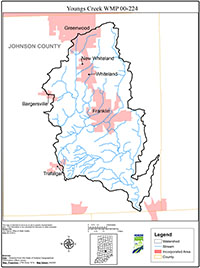
The Youngs Creek Watershed is located in central Indiana, approximately 15 miles south of Indianapolis. This watershed is included in the larger watersheds of the Driftwood River and the East Fork of the White River. The Youngs Creek Watershed is an 11-digit watershed that contains eight 14-digit subwatersheds, spans approximately 79,500 acres (24 square miles), and is entirely contained within Johnson County. Of the waterbodies in this watershed, Youngs Creek and Brewer Ditch were listed on Indiana’s most recent 303(d) List of Impaired Waterbodies for pathogens.
The Youngs Creek Watershed contains a unique mixture of both urban and agricultural land uses. Close proximity to Indianapolis has prompted the expansion of both population and urban land-uses in the northern portion of the watershed. However, agricultural land-uses, predominantly corn and soybean production, continue to dominate the watershed area. Notably, this watershed also contains a large portion of Atterbury State Fish and Wildlife Area, which features a rich variety of plant and animal resources.
The Youngs Creek Watershed: A Plan for the Future is the result of 22 months of gathering input, conducting research, and initiating discussions among state and local government representatives, agricultural producers, local businesses and industries, watershed residents, and interested citizens in order to identify and address watershed concerns. The Youngs Creek Advisory Group was formed to lead the process, and that group formed the following mission statement that captures the purpose of this project which is to assess the water quality of the Youngs Creek Watershed and promote watershed health for the benefit of its residents.
This Plan was created as a result of the group’s efforts to reduce pollution from nonpoint sources in the watershed. To accomplish this, the Advisory Group focused its attention on three main areas in the watershed:
- agricultural nonpoint source pollution, including both cropland and livestock farming;
- urban nonpoint source pollution and increasing impervious surfaces in the watershed; and
- the lack of a vegetated riparian buffer near many streams in the watershed.
The Advisory Group developed goals, objectives, and action items to address each of the three focus topics.