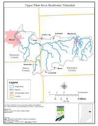
Location
The Upper White River Headwaters Watershed is located in east central Indiana, draining approximately 240 square miles in Randolph, and Delaware counties. Major streams included in the Total Maximum Daily Load (TMDL) report are White River, Colvin Ditch, Owl Creek, Peach Creek, Salt Creek, Sugar Creek, Eightmile Creek, Sparrow Creek, Cabin Creek, Little White River, Poplar Run, Stoney Creek, Little Stoney Creek, Mud Creek, Prairie Creek, Medford Drain, Muncie Creek, and unnamed tributaries.
History
A comprehensive survey of the Upper White River Headwaters Watershed was conducted by the Indiana Department of Environmental Management (IDEM) in 2001 and 2006. The primary cause of impairment is E. coli bacteria. Pollution sources in the watershed include nonpoint sources from agriculture and pastures, land application of manure and urban and rural run-off, as well as point sources from straight pipe discharges, home sewage treatment system disposal and combined sewer overflow outlets.
Pollutants Addressed
TMDLs for the Upper White River Headwaters Watershed are established E. coli and will address 21 impairments. Some of the recommended solutions to address the impairments include storm water controls, point source controls, manure management and habitat improvements.
Timeline
Kickoff meetings were held at the Farm Bureau Insurance Building in Muncie, IN and at the Randolph County 4-H Fairgrounds in Winchester, IN on May 26, 2011 during which IDEM staff described the TMDL Program and provided a summary of the available data.
On July 27, 2011, a draft TMDL meeting was held, during which IDEM staff provided an overview of the draft TMDL results.
The public comment period for this TMDL ran from July 26, 2011, to August 26, 2011.
U.S. EPA approved this TMDL on September 20, 2011.