Location
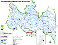
The Southern Whitewater River Watershed is located in southeastern Indiana along the Ohio state border and drains portions of Rush, Decatur, Union, Franklin, Dearborn and Ripley Counties. The watershed has a surface area of 412 square miles and drains a total of 1,370 square miles. Major waterbodies included in the Total Maximum Daily Load (TMDL) report are Whitewater River, Salt Creek, Bull Fork, Little Salt Creek, Pipe Creek, Clear Creek, Duck Creek, Blue Creek, Yellow Bank Creek, Gobles Creek, Logan Creek, Johnson Fork and Big Cedar Creek.
History
A preliminary survey of the Southern Whitewater River Watershed was conducted by Indiana Department of Environmental Management (IDEM) in 2007 through the probabilistic sampling program. Impairments include dissolved oxygen, E. coli, and PCB and total mercury in fish tissue. Potential pollution sources in the watershed include nonpoint sources from forested lands and pastures, land application of manure and urban and rural run-off, as well as point sources from straight pipe discharges, and home sewage treatment system disposal.
Parameters Addressed
IDEM completed a comprehensive sampling program in the watershed that was based on the current impairments. A total of 33 sites were assessed for general chemistry, nutrients, habitat, fish and macroinvertebrate communities, and stream flow. For a comprehensive list of all parameters please reference the approved work plan.
Timeline
Two TMDL public kickoff meetings were held on October 29, 2013. The first meeting was held at 2:00 PM (EDT) at the Franklin County Government Center, 1010 Franklin Avenue, Brookville, IN 47012. The second kickoff meeting was held at 6:00 PM (EDT) at the Batesville Middle School, 201 North Mulberry Street, Batesville, IN 47006. Meetings covered the same topics.
A Draft TMDL meeting was held at the Franklin County Government Center- Commissioners Room; 1010 Franklin Ave. Brookville, IN at 2:00 PM and Batesville Middle School- Commons; 201 Mulberry St. Batesville IN 6:00 PM on August 6, 2015 during which IDEM described the TMDL program and provided an overview of the draft TMDL results. A representative from the Whitewater River Watershed Project also provided information on current and future activities.
A 30 day public comment period followed the draft public meeting from August 6, 2015 to September 6, 2015.
Subsequent to its approval, inaccuracies in the final report were discovered by IDEM, who informed U.S. EPA in December 2017. IDEM explained that it had mischaracterized how bacteria TMDLs in the final Southern Whitewater River Watershed TMDL report were calculated. A memorandum from IDEM and revised decision document from U.S. EPA were issued as a result.
Additionally, an error in the total phosphorus WLA calculations for facilities in the watershed was discovered. As a result, IDEM recalculated the WLAs in error and provided a revised report. A public notice for the revision ran from February 5, 2020 to March 6, 2020. U.S. EPA approved the revisions on March 26, 2020.
The TMDL Report
- TMDL Report (Revised) [PDF]
- Whitewater River, Southern Decision Document (Revised 03/26/2020) [PDF]
- Southern Whitewater River Memorandum from IDEM [PDF]
Baseline Project 2013-2014
- 2013 Sampling and Analysis Work Plan for the Baseline Monitoring of the Southern Whitewater River Watershed [ZIP]
- Map of IDEM Monitoring Sites [PDF]
- Photos of IDEM Monitoring Sites [PDF]
- IDEM Surface Water Results Summary November 2013 - January 2014 [PDF]
- IDEM Surface Water Results Summary February 2014 - April 2014 [PDF]
- IDEM Surface Water Results Summary May 2014 - July 2014 [PDF]
- IDEM Surface Water Results Summary August 2014 - October 2014 [PDF]
- IDEM Fish Community Assessment Report [PDF]
- IDEM Macroinvertebrate Community Assessment Report [PDF]