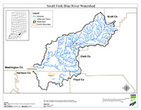
Location
The South Fork Blue River Watershed covers 126 square miles in South Central Indiana and is located primarily in Clark, Floyd, Harrison, Scott, and Washington counties. The primary bodies of water included in the Total maximum Daily Load (TMDL) report are the South Fork Blue River, Licking Creek, Bear Creek, Dutch Creek, Punch Run, Jeff Branch, Honey Run, and Springle Creek.
History
A preliminary survey of South Fork Blue River Watershed was conducted by Indiana Department of Environmental Management (IDEM) in 2000, 2005, and 2010 through the probabilistic and targeted sampling programs. Impairments in the watershed include E. coli and biological community impairments. Potential pollution sources in the watershed include nonpoint sources from agricultural lands and pastures, land application of manure and urban and rural run-off, as well as point sources from straight pipe discharges, and home sewage treatment system disposal.
A comprehensive survey of the South Fork Blue River Watershed was conducted by Indiana Department of Environmental Management (IDEM) in 2015. The primary cause of impairment is Escherichia coli (E. coli). Potential pollution sources in the watershed include nonpoint sources from row crop agriculture and pastures, urban and rural runoff, land application of manure, and point sources from straight pipe dischargers, and failing home sewage treatment disposal.
Pollutants Addressed
TMDLs for the South Fork Blue River Watershed are established for E. coli and will address 50 impairments. Some of the recommended solutions to address the impairments include stormwater controls, agricultural non-point source controls, manure management, and habitat improvements.
Timeline
Two South Fork Blue River public kickoff meetings were held on November 18, 2014. The first meeting was held at 2:00 PM (EST) at the Palmyra United Methodist Church, 14170 Greene St., Palmyra, IN. The second kickoff meeting was held at 6:30 PM (EST) at the Pekin Shelter House, 340 E. Park St., Pekin, IN. Meetings will cover the same topics.
One Draft TMDL Meeting was held on July 27, 2017 at 2:30PM (EDT) at the Palmyra Senior/Community Center, 13590 NE Greene St. Palmyra, IN 47164.
The 30-day public comment period was from July 7, 2017 through August 7, 2017.
The South Fork Blue River TMDL was approved by U.S. EPA Region 5 on September 15, 2017 for 50 impairments. TMDL reports identify and evaluate water quality problems in impaired water bodies and propose solutions to bring those waters into attainment with water quality standards.
The TMDL Report
Watershed Characterization Monitoring 2014-2015
- Map of IDEM Monitoring Sites [PDF]
- Photos of IDEM Monitoring Sites [PDF]
- IDEM Surface Water Results Summary November 2014 - October 2015 [PDF]
- IDEM Fish Community Assessment Report [PDF]
- IDEM Macroinvertebrate Community Assessment Report [PDF]
![Map of IDEM Monitoring Sites [PDF]](/idem/nps/files/tmdl_blue_river-south_fork_watershed_monitoring_sites.jpg)