 The Land & Aerial Survey Office has the primary role within Construction Management & District Support of providing support for the design, planning, construction, maintenance and operation of a superior transportation system enhancing safety, mobility and economic growth for the State of Indiana. LASO is committed in its support of INDOT central and district offices, as well as contracted consultants, in delivering quality, environmentally sensitive transportation projects as efficiently as possible, on scope, on schedule and on budget.
LASO is comprised of two primary functional areas: the Land Surveying Section and the Aerial Survey Section. Together they work as a team to provide high quality aerial imaging products and ground survey support. In addition to the two functional areas, LASO is also responsible for the maintenance and administration of the Indiana Statewide GNSS-GPS Real Time Network, known as the InCORS Network.
Land & Aerial Survey Office Operations
Land Survey Section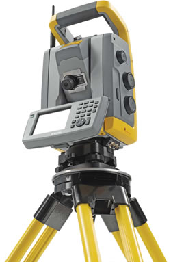
The Land Survey Section is responsible for establishing project specific geodetic control; placement and location of aerial image ground control; the maintenance and administration of Indiana’s statewide GNSS-GPS real time network, known as InCORS, as well as the INDOT benchmark database; providing geodetic and cadastral survey support; establishing survey specific standards, policies and procedures; and providing timely technical expertise, training, and support for all INDOT survey activities. In addition, the Land Survey Section establishes, administers, evaluates and procures new and emerging technologies in field survey equipment and systems for INDOT. Visit the Land Survey Section for more information about section responsibilities, requirements and standards.
Aerial Survey Section INDOT’s Aerial Survey Section has been providing aerial imagery and performing Aerial Photographic services for Indiana highway related projects since the late 1950s. In 2001 INDOT purchased a (at the time) state of the art aerial film camera, a digital scanner specifically for the aerial film, and Digital Photogrammetric workstations. Since then, the Aerial Survey Section has transitioned to using small Unmanned Aerial Systems (sUAS). The section uses an DJI M300 with P1 and L1 sensors to collect RBG images and LiDAR data. The Aerial Section procured the Wingtra Gen II, a VTOL fixed-wing sUAS, also with RGB and LiDAR capabilities. As drone and sensor technology advances, so will the fleet of the Aerial Survey Section. Visit the Aerial Survey Section for more information about section responsibilities, requirements and standards.
InCORS INDOT's Land Survey Section of the Indiana Department of Transportation coordinates a network of continuously operating reference stations (CORS). Each CORS site provides Global Navigation Satellite System (GNSS - GPS and GLONASS) carrier phase and code range measurements in support of 3-dimensional positioning activities throughout the state of Indiana. Visit the InCORS page for more information and to download Rinex data.
InGCS Welcome to the NEW Indiana Geospatial Coordinate System.
Through many hours and the help of many people, INDOT has been able to create and adopt a better defined coordinate system for the state of Indiana. In the coming months, INDOT will be posting more information and training sessions available for the new InGCS. For more information about the Indiana Geospatial Coordinate System please visit www.in.gov/indot/InGCS.htm
Manuals & Standards Links
- INDOT Design Manual
- INDOT Standard Specifications
- INDOT Work Zone Traffic Control Guidelines
- Indiana Manual on Uniform Traffic Control Devices
- Photogrammetric Mapping Specifications & Services Manual Version 2 - November 8,2013
- Photogrammetric Mapping Specifications & Services Manual Version 1 - April 1, 2011 ARCHIVED
Vendors Links
- Bentley Software
- Leica Geosystems
- PC Survey Software
- Positioning Solutions
- Seco
- Seiler Instruments
- Topcon
- Trimble
Related Links
- ASPRS (The American Society for Photogrammetry & Remote Sensing)
- Association of Indiana Counties
- Bureau of Land Management
- County Surveyors Association of Indiana
- Federal Highway Administration
- Geo Communicator
- IDEM (Indiana Department of Environmental Management)
- IDNR (Indiana Department of Natural Resources)
- IDNR Division of Water Benchmark Database
- IGIC (Indiana Geographic Information Council)
- Indiana Height Modernization Program (Height Mod)
- Indiana Land Surveys, Their Development & Uses
- ISPLS (Indiana Society of Professional Land Surveyors)
- Indiana State Board of Registration for Land Surveyors
- NBI (National Bridge Inventory Database)
- LASO (Land & Aerial Survey Office Facts)
- NGS (National Geodetic Survey)
- NSPS (National Society of Professional Surveyors)
- USGS (United States Geological Survey)
- 811 Indiana Underground (Holey Moley)
Contact Information
Eric Banschbach
Manager - Land & Aerial Survey Office
Indiana Department of Transportation
120 South Shortridge Road
Indianapolis, IN 46219
317-522-9736
ebanschbach@indot.in.gov
Office Location
Our office is located in the Materials and Tests Division Building on the East side of Indianapolis, one block south of the intersection of Shortridge Rd. and Washington St. (US40):
Click here for Interactive Map