Muskegon 3D Photogrammetry and Underwater Museum Interpretation CZ 540 – Michigan City, IN
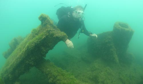
Built in 1872 as the Peerless, the Muskegon was a steamship that operated on the Great Lakes until 1911. Having functioned as a passenger freighter, a lumber-hooker, and a sand-sucker during its service, the Muskegon represents important innovations in engineering, commerce, transportation, and industry. An accidental fire on Oct. 6, 1910, burned the Muskegon just above the waterline while anchored in the Indiana Transportation Company’s dock on the north side of the Michigan City harbor. The Muskegon was towed out of the harbor and sunk just west of Michigan City by the Indiana Transportation Company on June 11, 1911.
The shipwreck now rests in 30-35 feet of water just 0.28 miles offshore from Mount Baldy on the Indiana Dunes National Lakeshore. Recreational divers discovered the ship in the early 1960s. For more than 50 years visitors have enjoyed this piece of maritime heritage as a popular recreational dive site.
Indiana University Center for Underwater Science received a Lake Michigan Coastal Grant for $33,360 to conduct underwater archaeological investigations of the historic shipwreck and produce an accurate 3D photogrammetric model, which will help to identify significant remaining features and their respective sensitivity. The results of this investigation and computer vision photogrammetry can be used for baseline monitoring and management, as well as an interpretive model for outreach and education. The only shipwreck in Indiana on the National Register of Historic Places, the Muskegon is a significant piece of Indiana maritime history and, will continue to be preserved and protected for future generations. The public can take a virtual tour of this historic shipwreck online.
Milroy Covered Bridge CZ 519 – Crown Point, IN
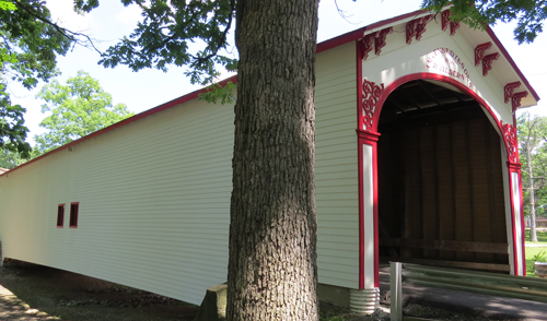
Located in Crown Point, Indiana, the Milroy Covered Bridge is 100 feet long but has an even longer history. Built originally in 1878 by Archibald and Emmett Kennedy over the Little Flatrock River in Henry County, the bridge was eventually disassembled and replaced in 1933.
The original structure was purchased for preservation by John Ward Wheeler, a Crown Point resident, and local Civil War hero, and reassembled over a gully at the Lake County Fairgrounds.
This bridge remained a landmark and backdrop for numerous family photos, Lake County events, and celebrations until 2012. In 2012, the bridge was closed, much to the disappointment of residents and visitors, after an inspection found structural deficiencies and needed repairs.
In 2015, the Lake County Board of Commissioners received a $100,000 Lake Michigan Coastal Grant to restore and repair this 140-year-old bridge. The project was completed in 2018. The bridge has been fully restored and provides a unique and historic interpretive area for cultural, historical, architectural, and artistic education.
The Lake County Board of Commissioners worked tirelessly with several partners to restore and preserve this treasured landmark as an enhancement to the Lake County Fairgrounds.
Cheney Run Watershed Drainage Area Plan CZ 648 – Michigan City, IN
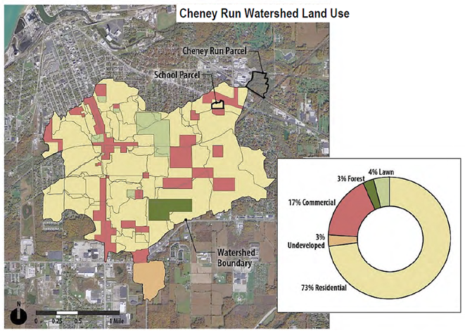
The Cheney Run Watershed has been identified by the Michigan City Sanitary District and the Trail Creek Watershed Partnership as the largest source of pollution delivered to Trail Creek, an important riparian corridor that discharges into Lake Michigan. Excessive flows and pollution from Cheney Run threaten the ecological and aesthetic integrity of Trail Creek, the water quality of Michigan City’s beaches, and water-based recreation along Lake Michigan. It is for these reasons the Michigan City Sanitary District sought LMCP Coastal Grant funds to develop the Cheney Run Watershed Drainage Area Plan.
Due to limited publically owned acreage in the area, the Michigan City Sanitary District was charged with evaluating public rights of way as well as creative options for private land. To achieve the project goals and thereby improve water quality, specific Best Management Practices (BMPs) for stormwater had to be identified and prioritized that would both engage with the community and effectively use public land. BMPs were identified based on cost-effectiveness, legal and regulatory impacts, and whether they are likely to achieve sustainable flow volume goals.
To better manage stormwater where it falls through temporary storage, infiltration, and filtration, this project sought to strategize how to implement stormwater BMPs upstream of the Cheney Run outfall and channel. This type of intervention would ultimately improve the water quality of urban stormwater flowing into Trail Creek. Strategies to increase the installation of green infrastructure projects within the watershed were also explored, such as projects that could be implemented on private land by the Michigan City Sanitary District, and a program to facilitate the use of stormwater BMPs by residents within the watershed. Should Michigan City dedicate the funds needed to launch and manage the program, the Residential Rain Garden cost-share program was identified as a promising strategy.
A suite of stormwater BMPs have been identified throughout the Cheney Run Watershed, as well as a feasibility study with cost estimates for each BMP. The final report - The Cheney Run Drainage Area Plan - addresses problematic peak discharge, upstream volume, and pollutant loading from the Cheney Run Watershed and, if implemented, will lead to water-quality improvements in Trail Creek and ultimately Lake Michigan. The 17 green infrastructure projects outlined in this report will improve water quality and quantity and provide numerous benefits for wildlife and residents.
For more information:
Michigan City Sanitary District
- Muskegon 3D Photogrammetry and Underwater Museum
Muskegon 3D Photogrammetry and Underwater Museum Interpretation CZ 540 – Michigan City, Indiana
Built in 1872 as the Peerless, the Muskegon was a steamship that operated on the Great Lakes until 1911. Having functioned as a passenger freighter, a lumber-hooker, and a sand-sucker during its service, the Muskegon represents important innovations in engineering, commerce, transportation, and industry. An accidental fire on Oct. 6, 1910 burned the Muskegon to just above the waterline while it was anchored in the Indiana Transportation Company’s dock on the north side of the Michigan City harbor. The Muskegon was then towed out of the harbor and sunk just west of Michigan City by the Indiana Transportation Company on June 11, 1911.
The shipwreck now rests in 30-35 feet of water just 0.28 miles offshore from Mount Baldy on the Indiana Dunes National Lakeshore. The ship was discovered by recreational divers in the early 1960s and for more than 50 years visitors have enjoyed this piece of maritime heritage as a popular recreational dive site.
Indiana University Center for Underwater Science received a Lake Michigan Coastal Grant for $33,360 to conduct underwater archaeological investigations of the historic shipwreck and produce an accurate 3D photogrammetric model, which will help to identify significant remaining features and their respective sensitivity. The results of this investigation and computer vision photogrammetry can be used for baseline monitoring and management, as well as an interpretive model for outreach and education. The only shipwreck in the state of Indiana on the National Register of Historic Places, the Muskegon is a significant piece of Indiana maritime history and will continue to be preserved and protected for future generations. The public can take a virtual tour of this historic shipwreck online.
- Milroy Covered Bridge
Milroy Covered Bridge CZ 519 – Crown Point, Indiana
Located in Crown Point, Indiana, the Milroy Covered Bridge is 100 feet long, but has an even longer history. Built originally in 1878 by Archibald and Emmett Kennedy over the Little Flatrock River in Henry County, the bridge was eventually disassembled and replaced in 1933.
The original structure was purchased for preservation by John Ward Wheeler, a Crown Point resident and local Civil War hero, and reassembled over a gully at the Lake County Fairgrounds.
There this bridge remained a landmark and backdrop for numerous family photos, Lake County events, and celebrations until 2012. In 2012, the bridge was closed, much to the disappointment of residents and visitors, after an inspection that found structural deficiencies and repairs that needed to be made.
The Lake County Board of Commissioners received a Lake Michigan Coastal Grant for $100,000 to use toward the restoration and repairs of this 140-year-old bridge in 2015. Completed in 2018, the bridge has been fully restored, and provides a unique and historic interpretive area for cultural, historical, architectural, and artistic education.
The Lake County Board of Commissioners worked tirelessly with several partners to restore and preserve this treasured landmark as an enhancement to the Lake County Fairgrounds.
- Cheney Run Watershed
Cheney Run Watershed Drainage Area Plan CZ 648 – Michigan City, Indiana
The Cheney Run Watershed has been identified by the Michigan City Sanitary District and the Trail Creek Watershed Partnership as the largest source of pollution delivered to Trail Creek, an important riparian corridor that discharges into Lake Michigan. Excessive flows and pollution from Cheney Run threaten the ecological and aesthetic integrity of Trail Creek, the water quality of Michigan City’s beaches, and water-based recreation along Lake Michigan. It is for these reasons the Michigan City Sanitary District sought LMCP Coastal Grant funds to develop the Cheney Run Watershed Drainage Area Plan.
Due to limited publically owned acreage in the area, the Michigan City Sanitary District was charged with evaluating public rights of way as well as creative options for private land. To achieve the project goals and thereby improve water quality, specific Best Management Practices (BMPs) for stormwater had to be identified and prioritized that would both engage with the community and effectively use public land. BMPs were identified based on cost effectiveness, legal and regulatory impacts, and whether they are likely to achieve sustainable flow volume goals.
In order to better manage stormwater where it falls through temporary storage, infiltration, and filtration, this project sought to strategize how to implement stormwater BMPs upstream of the Cheney Run outfall and channel. This type of intervention would ultimately improve water quality of urban storm water flowing into Trail Creek. Strategies to increase the installation of green infrastructure projects within the watershed were also explored, such as projects that could be implemented on private land by the Michigan City Sanitary District, and a program to facilitate the use of stormwater BMPs by residents within the watershed. Should Michigan City dedicate the funds needed to launch and manage the program, the Residential Rain Garden cost-share program was identified as a promising strategy.
A suite of stormwater BMPs have been identified throughout the Cheney Run Watershed, as well as a feasibility study with cost estimates for each BMP. The final report - The Cheney Run Drainage Area Plan - addresses problematic peak discharge, upstream volume, and pollutant loading from the Cheney Run Watershed and, if implemented, will lead to water-quality improvements in Trail Creek and ultimately Lake Michigan. The 17 green infrastructure projects outlined in this report will improve water quality and quantity and provide numerous benefits for wildlife and residents.
For more information:
Michigan City Sanitary District

