Benchmarks for Indiana
- Water
- Community Assistance & Information
- Current: Benchmarks for Indiana
Interactive Map for DNR and USGS

Ohio River Datum (also known as Sandy Hook Datum)
To search for more horizontal and vertical control information visit the National geodetic Survey.
INDOT Benchmarks (317) 610-7251 ext. 290
USGS Benchmarks (573)308-3500
Toll Free (888)ASK-USGS
Adams
Allen
Bartholomew
Benton
Blackford
Boone
Brown
Carroll
Cass
Clark
Clay
Clinton
Crawford
Daviess
Dearborn
Decatur
DeKalb
Delaware
Dubois
Elkhart
Fayette
Floyd
Fountain
Franklin
Fulton
Gibson
Grant
Greene
Hamilton
Hancock
Harrison
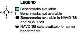
Below is a list of USGS Quadrangle pdf maps showing the benchmark locations.
- Aberdeen.PDF
- Acton.PDF
- Adams.PDF
- Akron.PDF
- Albion.PDF
- Alfordsville.PDF
- Alpine.PDF
- Alton.PDF
- AndersonSouth.PDF
- Andrews.PDF
- AngolaEast.pdf
- AngolaWest.pdf
- Arcola.pdf
- Argos.pdf
- Arney.PDF
- Ashley.pdf
- Atwood.pdf
- Auburn1.pdf
- Auburn2.pdf
- Aurora.pdf
- Azalia.pdf
- Bargersville.pdf
- Bartlettsville.pdf
- BassLake.PDF
- Beanblossom.PDF
- BearBranch.PDF
- BecksMill.PDF
- BedfordEast.PDF
- BedfordWest.PDF
- BeechGrove.PDF
- Beechwood.PDF
- Bellmore.PDF
- Belmont.PDF
- Berne.PDF
- Bippus.PDF
- Birdseye.PDF
- Blocher.PDF
- Bloomfield.PDF
- Bloomington.pdf
- Bluffton.PDF
- Boggstown.PDF
- Borden.pdf
- Boswell.PDF
- Branchville.pdf
- Bremen.PDF
- Bridgeport.pdf
- Bristol.pdf
- Bristow.pdf
- BronsonSouth.PDF
- Brownsburg.pdf
- Brownstown.pdf
- Brownsville.pdf
- Buffalo.pdf
- BunkerHill.pdf
- Burket.pdf
- Burlington.pdf
- ButlerEast.pdf
- Butlerville.pdf
- California.PDF
- CalumetCity.PDF
- CambridgeCity.PDF
- Camden.PDF
- Campbellsburg.PDF
- Carlos.PDF
- Carmel.PDF
- Cataract.PDF
- CedarGrove.PDF
- Cedarville.PDF
- Cedarville2.PDF
- CenterPoint.PDF
- Charlestown.PDF
- Chesterton.PDF
- ChestnutRidge.PDF
- Churbusco.PDF
- ClayCity.PDF
- Clayton.PDF
- ClearCreek.PDF
- ClearLake.PDF
- Clermont.PDF
- CliftyFalls.PDF
- ClintonFalls.PDF
- Cloverdale.PDF
- CoalCity.PDF
- Colfax.PDF
- ColumbiaCity.PDF
- Columbus.PDF
- Connersville.PDF
- Cope.PDF
- Corunna.PDF
- CorydonWest.PDF
- Cosmos.PDF
- CrossPlains.PDF
- Crothersville.PDF
- Culver.PDF
- Cumberland.PDF
- Cuzco.PDF
- Cynthiana.PDF
- Dale.PDF
- Danville.PDF
- Decatur.PDF
- DeerCreek.PDF
- Deerfield.PDF
- Delphi.PDF
- Depauw.PDF
- Deputy.PDF
- Domestic.PDF
- Donaldson.PDF
- Dubois.PDF
- Dugger.PDF
- Dyer.PDF
- Eaton.PDF
- Edinburgh.PDF
- Ege.PDF
- Elizabethtown.PDF
- Elkhart.PDF
- Elkinsville.PDF
- Eminence.PDF
- English.PDF
- EnglishLake.PDF
- Epsom.PDF
- Fairbanks.PDF
- Fairmount.PDF
- Farmland.PDF
- Fayette.PDF
- Fishers.PDF
- Flora.PDF
- Foraker.PDF
- ForrestHill.PDF
- FortWayneEast.PDF
- FortWayneWest.PDF
- FountainCity.PDF
- Fountaintown.PDF
- Fowler.PDF
- Francesville.PDF
- Frankfort.PDF
- Franklin.PDF
- Frankton.PDF
- Fredricksburg.PDF
- Freedom.PDF
- FrenchLick.PDF
- Fulda.PDF
- Galveston.PDF
- Garrett.PDF
- Garrett2.PDF
- Gary.PDF
- GasCity.PDF
- Gaston.PDF
- Gatchel.PDF
- Geneva.PDF
- Georgia.PDF
- Gilman.PDF
- Glendale.PDF
- Goodland.PDF
- Goshen.PDF
- Gosport.PDF
- Grabill.PDF
- Grammer.PDF
- Greenbrier.PDF
- Hicksville.pdf
- Hutton.pdf
- IndianapolisEast.PDF
- IndianapolisWest.PDF
- Inwood.PDF
- Iona.PDF
- Jacksonburg.PDF
- Jasonville.PDF
- Jasper.PDF
- Jasper2.PDF
- Jeffersonville.PDF
- Jonesville.PDF
- Kasson.PDF
- Kendallville.PDF
- Kent.PDF
- LaFontaine.PDF
- LaPorteEast.PDF
- LaPorteEast2.PDF
- Lacrosse.PDF
- Lacrosse2.PDF
- LafayetteEast.PDF
- LafayetteEast2.PDF
- LafayetteEast3.PDF
- LafayetteWest.PDF
- LafayetteWest2.PDF
- Lagrange.PDF
- Lagrange2.PDF
- Lagro.PDF
- LakeCalumet.PDF
- LakeCalumet2.PDF
- LakeWawasee.PDF
- LakeWawasee2.PDF
- LakeWawasee3.PDF
- LakeWawasee4.PDF
- Lakeville.PDF
- Lakeville2.PDF
- Lapel.PDF
- Laud.PDF
- Laud2.PDF
- Laud3.PDF
- Leavenworth.PDF
- Lebanon.PDF
- Lebanon2.PDF
- Leesburg.PDF
- LewisCreek.PDF
- Lewisville.PDF
- LibertyCenter.PDF
- Ligonier.PDF
- LinnGrove.PDF
- LinnGrove2.PDF
- LittleYork.PDF
- Livonia.PDF
- Lizton.PDF
- Logansport.PDF
- Logansport2.PDF
- Loogootee.PDF
- Lorane.PDF
- Lorane2.PDF
- Lowell.PDF
- Lowell2.PDF
- Lydick.PDF
- Lydick2.PDF
- Lynn.PDF
- Lyons.PDF
- Macy.PDF
- Majenica.PDF
- Maples.PDF
- Maples2.PDF
- Marietta.PDF
- Marion.PDF
- Markle.PDF
- Martinsville.PDF
- Maxville.PDF
- Maxville2.PDF
- Maywood.PDF
- McCordsville.PDF
- McCoysburg.PDF
- Mechanicsburg.PDF
- Medora.PDF
- Mentone.PDF
- Merriam.PDF
- MichiganCityEast.PDF
- MichiganCityEast2.PDF
- MichiganCityWest.PDF
- MichiganCityWest2.PDF
- Michigantown.PDF
- Middlebury.PDF
- Middletown.PDF
- Milan.PDF
- Milford.PDF
- Millersburg.PDF
- Millersburg2.PDF
- Milltown.PDF
- Milroy.PDF
- Mitchell.PDF
- Modesto.PDF
- Mongo.PDF
- Monon.PDF
- MononNE.PDF
- MonroeCity.PDF
- Montgomery.PDF
- Montpelier.PDF
- MooresvilleEast.PDF
- MooresvilleWest.PDF
- MountAyr.PDF
- MountAyr2.PDF
- MountEtna.PDF
- MountGilboa.PDF
- MountVernon.PDF
- Mulberry.PDF
- MuncieEast.PDF
- MuncieWest.PDF
- NewAlbany.PDF
- NewCarisle.PDF
- NewCarisle2.PDF
- NewCorydon.PDF
- NewHarmony.PDF
- NewPoint.PDF
- NewRoss.PDF
- Nineveh.PDF
- Noblesville.PDF
- Noblesville2.PDF
- NorthLiberty.PDF
- NorthManchesterNorth.PDF
- NorthManchesterNorth2.PDF
- NorthManchesterSouth.PDF
- NorthSalem.PDF
- NorthVernon.PDF
- NorthWebster.PDF
- NorthWebster2.PDF
- OliverLake.PDF
- OliverLake2.PDF
- Omega.PDF
- Onward.PDF
- Oolitic.PDF
- Orland.PDF
- Ormas.PDF
- Osceola.PDF
- Osceola2.PDF
- Osgood.PDF
- Ossian.PDF
- Otisco.PDF
- Ottwebrein.PDF
- Otwell.PDF
- Owensburg.PDF
- Owensburg2.PDF
- Palmer.PDF
- Paoli.PDF
- Paragon.PDF
- Parr.PDF
- Peoria.PDF
- Perrysville.PDF
- Pershing.PDF
- Pershing2.PDF
- Peru.PDF
- Peru2.PDF
- Peru3.PDF
- Petroleum.PDF
- Pierceton.PDF
- Pierceton2.PDF
- Pierceton3.PDF
- Pierceton4.PDF
- Pierceton5.PDF
- Pierceton6.PDF
- Pierceville.PDF
- PineVillage.PDF
- PineVillage2.PDF
- Plainfield.PDF
- Plainfield2.PDF
- Plainfield3.PDF
- Plainville.PDF
- Plymouth.PDF
- Plymouth2.PDF
- Plymouth3.PDF
- Poe.PDF
- Poe2.PDF
- Poland.PDF
- Portage.PDF
- Portage2.PDF
- Poseyville.PDF
- Pyrmont.PDF
- Pyrmont2.PDF
- Quincy.PDF
- RaysCrossing.PDF
- Redkey.PDF
- Reelsville.PDF
- Reelsville2.PDF
- Remington.PDF
- Rensselaer.PDF
- Richmond.PDF
- Richvalley.PDF
- Ridgeville.PDF
- Riverwood.PDF
- Riverwood2.PDF
- Roachdale.PDF
- Roann.PDF
- Rochester.PDF
- Rochester2.PDF
- Romney.PDF
- Romney2.PDF
- Rosston.PDF
- Rossville.PDF
- Rusk.PDF
- Rusk2.PDF
- Russellville.PDF
- Russiaville.PDF
- Rutland.PDF
- Rutland2.PDF
- SaintJoe.PDF
- SaintJoe2.PDF
- SaintMeinrad.PDF
- Salem.PDF
- SalineCity.PDF
- SanJacinto.PDF
- SanJacinto2.PDF
- SanPierre.PDF
- Sandborn.PDF
- SandyHook.PDF
- Schneider.PDF
- Schneider2.PDF
- Scotland.PDF
- Scottsburg.PDF
- Scottsburg2.PDF
- Seymour.PDF
- Shannondale.PDF
- Shelby.PDF
- Shelby2.PDF
- Shelby3.PDF
- Sheldon.PDF
- Sheldon2.PDF
- Shipshewana.PDF
- Shipshewana2.PDF
- Shoals.PDF
- SilverLake.PDF
- Solitude.PDF
- Somerset.PDF
- SouthBendEast.PDF
- SouthBendEast2.PDF
- SouthBendWest.PDF
- SouthBendWest2.PDF
- SouthWhitleyEast.PDF
- SouthWhitleyEast2.PDF
- SouthWhitleyEast3.PDF
- SouthWhitleyWest.PDF
- SouthWhitleyWest2.PDF
- SouthWhitleyWest3.PDF
- SouthWhitleyWest4.PDF
- SouthWhitleyWest5.PDF
- Spartanburg.PDF
- Speed.PDF
- Spencer.PDF
- Springville.PDF
- Springville2.PDF
- St.John.PDF
- St.John2.PDF
- Stillwell.PDF
- Stockwell.PDF
- Stockwell2.PDF
- Story.PDF
- Stroh.PDF
- Stroh2.PDF
- Tab.PDF
- Tab2.PDF
- Tampico.PDF
- Taswell.PDF
- TellCity.PDF
- Thorntown.PDF
- Tipton.PDF
- Topeka.PDF
- Trafalgar.PDF
- Trafalgar2.PDF
- Tunnelton.PDF
- TwelveMile.PDF
- Uniondale.PDF
- Unionville.PDF
- Valeene.PDF
- Vallonia.PDF
- Valparaiso.PDF
- VanBuren.PDF
- Velpen.PDF
- Velpen2.PDF
- Vernon.PDF
- Versailles.PDF
- Volga.PDF
- WabashIsland.PDF
- Wabash.PDF
- Wadesville.PDF
- Wakarusa.PDF
- Walkerton.PDF
- Wallace.PDF
- Warren.PDF
- Warsaw.PDF
- Washington.PDF
- Waterloo.PDF
- Waterloo2.PDF
- Westfield.PDF
- Westport.PDF
- Westville.PDF
- Wheatland.PDF
- Wheeling.PDF
- Whiting.PDF
- Whiting2.PDF
- Williamsport.PDF
- Willshire.PDF
- Winamac.PDF
- Winchester.PDF
- Winchester2.PDF
- Wolcott.PDF
- Wolcottville.PDF
- WoodburnNorth.PDF
- WoodburnNorth2.PDF
- Wren.PDF
- Wren2.PDF
- Wren3.PDF
- YoungAmerica.PDF
- Zanesville.PDF
- Zanesville2.PDF
- Zionsville.PDF
- Zionsville2.PDF