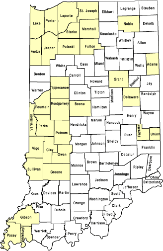
This series of reports describes results of water resource investigations, primarily by county.
Earliest bulletins were primarily basic ground-water data reports and include:
- pumpage, water levels, and water quality
- text, figures, tables, and plate maps
- water well records having geologic descriptions
Later reports (after 1968) became more interpretive.
- maps of data points, bedrock topography, unconsolidated thickness, principal water- bearing units, ground-water availability, and potentiometric surface
- descriptions and cross sections of bedrock, unconsolidated deposits, and principal water-bearing units
- information on potential yield and development potential, aquifer coefficients, water levels, water quality, recharge, and discharge for principal aquifers
See county list below for individual bulletins.
- Water Levels in Indiana
- Water Level Records of Indiana
- Ground-Water Levels in Indiana: 1955 through 1962
Note: For counties not shaded or listed below, no bulletins were completed.

- Adams County
- Boone County
- Clay County
- Delaware County
- Fayette County
- Fountain County
- Fulton County
- Gibson County
- Grant County
- Greene County
- Jasper County
- Lake County
- LaPorte County
- Marshall County
- Montgomery County
- Newton County
- Noble County
- Owen County
- Parke County
- Porter County
- Pulaski County
- Putnam County
- Starke County
- St. Joseph County
- Sullivan County
- Tippecanoe County
- Union County
- Vanderburgh County
- Vermillion County
- Vigo County
