History
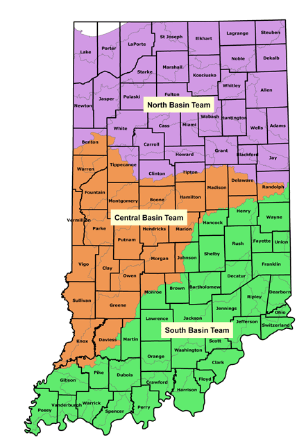
The Engineering Service Center (ESC) within the Division of Water was created in 1999 as part of an overall reorganization of the division. Before the creation of ESC, engineering staff were scattered throughout the division, with varying responsibilities and skill sets. The intent of ESC was to consolidate the engineers into one area to facilitate learning and growth, provide equivalent experiences, and allow for operational efficiencies. ESC was then divided into three “basin teams” based on watersheds into North, Central and South teams.
- ESC worked with Indiana Chapter of the American Council of Engineering Consultants (ACEC) to develop the The General Guidelines for the Hydrologic-Hydraulic Assessment of Floodplains in Indiana, a major expansion of previous guidance on developing hydrologic and hydraulic modeling for Construction in a Floodway permitting and FEMA Letter of Map Revisions. Establishment of the guidelines allowed for ESC staff to streamline and standardize model review, both improving model review time and freeing ESC staff time for other initiatives.
- ESC partnered with Prison Enterprises Network (PEN) to digitize existing Flood Insurance Rate Maps (FIRMs), ahead of FEMA initiatives to digitize data. Indiana was the first state in the nation to have a full digital version of its FIRMs.
- In 2004, ESC became a Cooperating Technical Parter with FEMA, in order to manage the Map Modernization program for updating Flood Insurance Rate Maps. From 2004-2008, ESC was awarded more than $9 million in grant funding to convert 82 of the 92 counties to digital mapping and run through the FEMA map adoption procedures for each county.
- ESC has developed state-of-the-art, award-winning applications, including the Indiana Floodplain Information Portal (INFIP), the Indiana Peak Discharge Determination System, and the Indiana Hydrologic and Hydraulic Model Library.
- In 2012, ESC was awarded a grant by the Indiana Office of Community and Rural Affairs (OCRA) to develop 18,500 miles of hydraulic modeling and mapping, resulting in more than 90% of Indiana stream miles being covered by high-quality floodplain information. This project was concluded in October 2018, and published on INFIP.
Contact the Engineering Service Center

North Basin Team section manager Adam Bales (abales@dnr.in.gov)
Central Basin Team section manager David Knipe (dknipe@dnr.IN.gov)
South Basin Team section manager is currently vacant

