Location
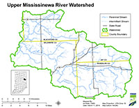
The Upper Mississinewa River Watershed is located in east-central Indiana along the Ohio state border and drains portions of Blackford, Delaware, Grant, Jay and Randolph counties. The watershed has a surface area of 315 square miles and drains a total of 446 square miles. Major waterbodies included in the Total Maximum Daily Load (TMDL) report are Mississinewa River, Halfway Creek, Big Lick Creek, Little Lick Creek, Redkey Run, Flesher Creek, Townsand Lucas Ditch, Moore Prong, Rees Ditch, Bosman Ditch, Studebaker Ditch, Brush Creek, Bear Creek and Campbell Creek.
History
A preliminary survey of the Upper Mississinewa River Watershed was conducted by Indiana Department of Environmental Management (IDEM) in 2008 through the probabilistic sampling program. Impairments include E. coli, biological impairments, and PCB and total mercury in fish tissue. Potential pollution sources in the watershed include nonpoint sources from agricultural lands and pastures, land application of manure and urban and rural run-off, as well as point sources from straight pipe discharges, and home sewage treatment system disposal.
Parameters Addressed
IDEM completed a comprehensive sampling program in the watershed that was based on the current impairments. Approximately 35 sites were assessed for general chemistry, nutrients, habitat, fish and macroinvertebrate communities, and stream flow. For a comprehensive list of all parameters please reference the approved work plan.
Timeline
Two Upper Mississinewa public kickoff meetings were held on March 13, 2014. The first meeting was held at 2:30 PM (EDT) at the Davis-Purdue Agricultural Center, 6230 N State Road 1, Farmland, IN. The second kickoff meeting was held at 6:30 PM (EDT) at the Hartford City Annex Building, 121 North High Street, Hartford City, IN. Meetings covered the same topics.
The TMDL Report
- Upper Mississinewa River Watershed TMDL [PDF]
- Upper Mississinewa River Watershed TMDL Decision Document [PDF]
Baseline Project 2014-2015
- Map of IDEM Monitoring sites [PDF]
- Photos of IDEM Monitoring sites [PDF]
- IDEM Surface Water Results Summary April 2014 - April 2015 [PDF]
- IDEM Fish Community Assessment Report [PDF]
- IDEM Macroinvertebrate Community Assessment Report [PDF]

