Summary
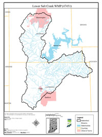
In 2016, IDEM initiated a Total Maximum Daily Load (TMDL) study of the Lower Salt Creek Watershed. Local interest from Jackson, Lawrence and Monroe counties, City of Bloomington and Bedford and local landowners led to IDEM selecting the Lower Salt Creek Watershed for a TMDL/Watershed characterization study. The Lower Salt Creek Project launched in early 2021 as a result from a Section 205j grant awarded to develop the Lower Salt Creek Watershed Management Plan. The Lower Salt Creek Watershed includes portions of Bloomington and Bedford, Oolitic, Avoca, Harrodsburg, Coneyville, Bartlettsville, Fayettville, and Coxton. The watershed includes a variety of land uses including agricultural, forest and natural areas, including nature preserves and national forest, as well as urban and urbanizing land uses. The Clear Creek drainage is a mix of urban and forested land, while the Little Salt Creek and Knob Creek drainages are almost entirely forested with some residential and
agricultural land. Salt Creek includes a mix of agricultural, forested, and urban/urbanizing land uses. Much of the watershed is covered by highly erodible soils. The presence of karst, high number of quarries and history of legacy pollution contamination associated with Superfund and Resource Conservation and Recovery Act (RCRA) sites are also of concern in the Lower Salt Creek Watershed.
Based on these concerns, the Lawrence County SWCD approached community groups and individuals throughout the watershed that might be interested in working with them to assess and improve water quality within Lower Salt Creek and its tributaries. Identified potential stakeholders include: Lawrence and Monroe County SWCD and NRCS staff; Monroe County, City of Bloomington, City of Bedford, and Indiana University MS4s; Indiana DNR; Indiana State Department of Agriculture; Lawrence and Monroe County surveyors, parks departments and Purdue Extension; Hoosier National Forest hydrologists and biologists; local landowners, educators and more. This group formed a Steering Committee, conducted windshield surveys of the watershed, and held several meetings open to the public in order to generate input in the development of a watershed management plan for Lower Salt Creek Watershed. Based on water quality data and the watershed inventories conducted during the project, nutrients, sediment, and E. coli, were identified as water quality problems in the watershed.
The WMP is a strategy for achieving water quality goals by characterizing the watershed, setting goals and actions steps, and developing an implementation plan to address documented problems. The Lower Salt Creek WMP meets the requirements of IDEM’s 2009 Watershed Management Plan Checklist and was approved by IDEM and EPA in December 2022.

