Summary
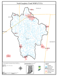
The North Laughery Creek watershed is 107,139 acres in size and is located in portions of Ripley, Decatur, and Franklin counties. There are approximately 341 miles of streams in the watershed. Primary land use types in the watershed include forest (41%), agricultural (38%), and hay/pasture (12%). Roughly 76% of the watershed is considered highly erodible or potentially highly erodible.
In December 2019, Historic Hoosier Hills RC&D received funding through a Section 319 grant to develop and watershed management plan and complete an initial round of implementation. IDEM conducted the water quality monitoring for the project in conjunction with the development of the Laughery Creek Total Maximum Daily Load (TMDL) Report. Based on water quality sampling conducted by IDEM and the watershed inventories conducted during North Laughery Creek watershed project, E. coli, nutrients, sedimentation, and impaired biotic communities were identified as water quality problems. According to Indiana’s 2022 Integrated Report, there are approximately 119 miles of stream segments listed as impaired for E. coli (112.3 miles), impaired biotic communities (28.7 miles), dissolved oxygen (27 miles), and nutrients (6.8 miles).
The WMP is a strategy for achieving water quality goals by characterizing the watershed, setting goals and actions steps, and developing an implementation plan to address documented problems. North Laughery Creek WMP meets the requirements of IDEM’s 2009 Watershed Management Plan Checklist and was approved by IDEM and EPA in August 2022.