Summary
Hancock County Soil and Water Conservation District (SWCD) retained Davey Resource Group (Davey) to conduct field data collection and write a Watershed Management Plan (WMP) for Brandywine Creek Watershed. The project was funded by an Indiana Department of Natural Resources (IDNR) Lake and River Enhancement Program (LARE) grant with a cash and in-kind services match provided by Hancock County SWCD.
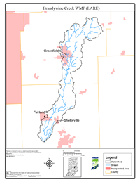
The headwaters of Brandywine Creek originate in northeastern Hancock County, Indiana. Brandywine Creek generally flows southwest to a point where it debouches to Big Blue River in northwestern Shelby County, Indiana. Brandywine Creek is part of the Mississippi River Basin. Brandywine Creek Watershed is a 10-digit hydrologic unit code (HUC) watershed (0512020403) comprised of 27,615 hectares (65,238 acres). It is composed of four, 12-digit HUC subwatersheds including: Willow Branch-Brandywine Creek Subwatershed (051202040301), Richey Ditch- Brandywine Creek Subwatershed (051202040302), Andis Ditch-Brandywine Creek Subwatershed (051202040303), and Swamp Creek-Brandywine Creek Subwatershed (051202040304).
Cultivated cropland is the predominant land use type comprising just over 78% of the total watershed area. A total of 11.5% of the watershed is developed commercial, industrial, and residential areas as well as developed open space such as athletic fields and golf courses. Brandywine Creek Watershed is trending toward more rapid development due to its close proximity to Indianapolis, especially in the vicinity of Interstate (I)-70 and I-74 corridors which offer convenient access to Indianapolis.
A total of 14 sample sites were established within the watershed as part of this study. A reference site was also established on Sugar Creek. Data collected included temperature, pH, specific conductivity, dissolved oxygen, total phosphorus, orthophosphate phosphorus, ammonia, nitrate + nitrite, total Kjeldahl nitrogen (TKN), total suspended solids (TSS), turbidity, discharge, E. coli, macroinvertebrate communities, and habitat data.
Stakeholder water quality concerns were collected at public and steering committee meetings and solicited by steering committee members. The steering committee determined whether each concern was supported by available data. The steering committee identified specific problems relating to each concern that was supported by data and on which the group wished to focus.
Goals were developed to address the identified problem categories and improve water quality in Brandywine Creek Watershed. Five primary goals selected include reducing E. coli concentrations to below the state standard, reducing sediment to below the water quality target, reducing nutrient loads to below water quality targets, increasing public awareness of water quality issues, and reducing flood damages.
Critical areas were identified and described for implementation of best management practices (BMPs) to remediate nonpoint source pollution. An Action Register was developed to facilitate implementation of the WMP. It includes specific objectives to be carried out in the process of working toward accomplishing each water quality improvement goal for Brandywine Creek Watershed. Also included in the Action Register is the target audience for each water quality improvement objective, objective milestones, estimated costs for implementing each objective, and possible partners as well as technical assistance resources that may be beneficial for objective implementation. WMP implementation progress will be tracked using a combination of social indicators, administrative indicators, and environmental indicators.
Several well-known cost-share programs are offered by the USDA NRCS, ISDA, IDNR, IDEM and other less well-known programs that could be used to financially support the implementation of recommended BMPs. A large variety of established institutional resources and other potential institutional resources exist to aid in water quality improvement efforts.