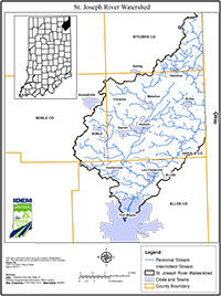
Location
The St. Joseph River watershed (SJRW) is in northwestern Ohio, south central Michigan, and northeast Indiana. The watershed encompasses approximately 1,085 square miles and drains to the Maumee River. The SJRW consists of one 8-digit hydrologic unit (hydrologic unit code [HUC] 04100003) that is further subdivided into eight 10-digit hydrologic units. The Indiana portion of the SJRW consists of 591 square miles including Fish Creek (0410000304), Cedar Creek (0410000307), Sol Shank Ditch (0410000305), Matson Ditch (0410000306), and St. Joseph River (0410000308) 10-digit HUC watersheds.
History
U.S. EPA’s goal for the St. Joseph River Watershed (SJRW) multi-state TMDL project was to assist the Ohio Environmental Protect Agency (Ohio EPA), the Indiana Department of Environmental Management (IDEM), and the Michigan Department of Environment Quality (MDEQ) in the development of multi-state TMDLs for impaired waterbodies of the SJRW. The TMDL document presents the results of a TMDL study for the Indiana-portion of the SJRW. The watershed characterization and source assessment are presented for the entire SJRW and rely, in part, on valuable background information provided in watershed improvement plans, state agency issued water quality reports, and many additional existing studies. The linkage analyses, TMDLs, allocations, and implementation plan framework are specific to the Indiana-portion of the SJRW.
Parameters Addressed
Fixed water quality monitoring sites are sampled for nutrients and total suspended solids (TSS) a few times per year in Indiana, including most recently in 2014. Indiana Department of Environmental Management (IDEM) listed six segments of Cedar Creek and one segment of Dosch Ditch for nutrient impairments, 18 segments for impaired biotic communities (IBC), and one segment each on Fish Creek and Peckhart Ditch for dissolved oxygen in Indiana’s draft Clean Water Act (CWA) 303(d) list IDEM also found two segments of the mainstem St. Joseph River and 57 segments in the SJRW to be impaired for recreational uses. Segments of the SJR, Cedar Creek, and Davis Ditch are impaired by polychlorinated biphenyls but these human health use impairments were not addressed in this TMDL project. E. coli TMDLs were developed at 17 sites in the watershed to address 60 impaired segments. TSS TMDLs were developed at 7 sites to address 7 segments with impaired biotic communities (IBC). TP TMDLs were developed at 8 sites to address 7 segments impaired by nutrients, 18 segments with IBCs, and 2 segments impaired by low dissolved oxygen.
Timeline
A Draft TMDL Meeting was held on January 31, 2017 at 5:00PM (EST) at the Allen County SWCD office, 3718 New Vision Drive, Fort Wayne, IN 46845.
A 30-day public comment period for the draft St. Joseph River Watershed TMDL report began on January 11, 2017 and ended on February 9, 2017.
Upon addressing comments, a second 30-day public comment period for the draft began on May 12, 2017 and ended on June 12, 2017.
The St. Joseph (Lake Erie) TMDL was approved by U.S. EPA Region 5 on October 26, 2017 for 58 bacteria (E. coli), 15 nutrient (total phosphorus), and 12 sediment (total suspended solid) impairments.
The TMDL Report
- St. Joseph River (Lake Erie) Watershed TMDL Report [PDF]
- St. Joseph River (Lake Erie) Watershed Decision Document (Revised (03/01/2019) [PDF]

