Summary
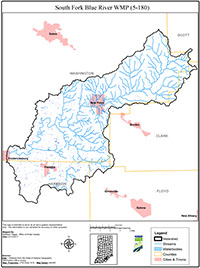
The South Fork Blue River Watershed is approximately 81,000 acres located mainly in southeastern Washington County with portions of the watershed extending into Harrison, Clark, Floyd, and Scott counties. There are approximately 240 miles of streams and tributaries in the watershed. There are fewer perennial streams in the southwest portion of the watershed due to its sensitive karst topography which covers approximately half of the watershed. Primary land use types in the watershed include forest (46%), pasture/hay (30%), and cultivated crops (17%). About 60% of the watershed is classified as highly erodible and is at a severe risk for erosion.
In November 2014, the Washington County Soil and Water Conservation District (SWCD) received funding through a Section 205j Water Quality Planning grant to develop a watershed management plan and conduct an education/outreach program. IDEM conducted the water quality sampling for the project in conjunction with the development of the South Fork Blue River Total Maximum Daily Load (TMDL) Report. Based on water quality sampling conducted by IDEM and the watershed inventories conducted during the South Fork Blue River watershed project, E. coli, excess nutrients, sedimentation, dissolved oxygen, and impaired biotic communities were identified as water quality problems. The South Fork Blue River Watershed has approximately 143 miles of stream segments listed on the 2018 Draft 303 (d) list of impaired streams for E. coli (116.7 miles), impaired biotic communities (IBC) (14.3 miles), and E. coli and IBC (12.6 miles).
The WMP is a strategy for achieving water quality goals by characterizing the watershed, setting goals and actions steps, and developing an implementation plan to address documented problems. The South Fork Blue River WMP meets the requirements of IDEM’s 2009 Watershed Management Plan Checklist and was approved by IDEM and EPA in October 2017.

