Summary
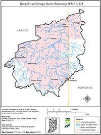
The Deep River/Portage Burns watershed, identified as the hydrologic unit code (HUC) watershed 0404000105, covers a drainage area of approximately 180 square miles in northwestern Indiana, of which 104 square miles are located in Lake County, and 20 square miles are located in Porter County. There are approximately 125 miles of impaired streams within the watershed boundary.
Turkey Creek and its tributaries drain the northwestern part of the watershed into the upper end of Lake George. Deep River and its major tributaries, Beaver Dam Ditch and Niles Ditch, drain the southern and eastern parts of the watershed before flowing into Lake George. Deep River flows through Lake George and continues through Hobart, Lake Station, and East Gary, Indiana, draining the Deep River/Turkey Creek watershed into Burns Ditch. A majority of the major stream channels in the area are no longer in a natural state, as all have undergone stream channel alteration and many have been completely constructed or reconstructed for drainage purposes.
The first comprehensive planning effort to improve water quality and restore aquatic habitats in the Deep River-Portage Burns Waterway Watershed dates back to the 2002 Deep River-Turkey Creek Watershed Management Plan (WMP). The City of Hobart initiated the development of the Deep River-Turkey Creek WMP following a dredging project that resulted in more than 590,000 cubic yards of sediment being removed from Lake George at a cost of over two million dollars to City tax payers. Given the cost of dredging the City of Hobart realized a long-term solution was needed to reduce future sediment and nutrient loads to Lake George which threatened the City’s lakefront and downtown revitalization efforts.
The Deep River/Turkey Creek watershed encompasses areas of diverse land use including significant agricultural areas in the southern portion to predominately urban areas in the northern portion of the watershed. This region includes the communities of Hobart, Merrillville, Crown Point, and Winfield, as well as small portions of other communities in the area, such as Griffith, Schererville, Gary, Portage, New Chicago, and Lake Station.
In 2011, the Northwestern Indiana Regional Planning Commission (NIRPC) identified the Deep River-Portage Burns Waterway Watershed as a priority in the Northwest Indiana Watershed Management Framework. The decision to include the watershed as a priority was based on persisting water quality issues, but more importantly, because stakeholders continued to express interest in reinvigorating these past efforts. With substantial changes in land use being evident, there was enough support to update the previous watershed plans into a single comprehensive plan.
NIRPC was awarded a 319 grant proposal for the fiscal year 2013 funding cycle. The grant’s purpose was to develop a WMP, an education/outreach program, and implement best management practices (BMPs) in the watershed. In October of 2016, a comprehensive WMP for the Deep River-Portage Burns Watershed was approved by IDEM and the U.S. EPA.
After the completion and approval of the WMP, three BMPs were installed during the grant. The Region 5 Load Estimation Model was used to provide sediment and nutrient load reductions for each practice implemented as a result of this project. These practices resulted in the reduction of approximately 922 lbs./yr. of sediment, 40 lbs./yr. of phosphorus, and 67 lbs./yr. of nitrogen from entering watershed tributaries.

