Summary
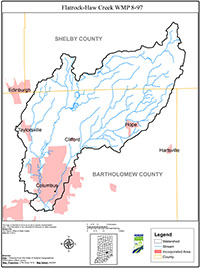
The 10-digit Flatrock-Haw Creek Watershed encompasses approximately 131 square miles (83,868 acres) in the 8 digit Flatrock-Haw Creek Basin. The majority of this acreage lies in Bartholomew County, with a portion of the watershed area lying in Shelby County.
The land use in the watershed is mostly agricultural (78%), and is characterized by corn and soybeans with some pasture operations. Livestock farms vary in size throughout the watershed from small family farm operations to larger confined feeding operations. Developed areas also make up a portion of the watershed, and are the next largest percentage of land use type in the watershed. The city of Columbus is almost entirely contained within this watershed and is the largest urban area in the watershed.
The mission of the Bartholomew County Soil and Water Conservation District (BCSWCD) is to provide assistance and education to help empower Bartholomew County residents to protect and preserve their natural resources. With the Flatrock-Haw Creek Watershed adjacent to the Clifty Creek Watershed the BCSWCD hopes to expand on the area residents’ knowledge, continue to build partners in the area, and improve a larger section of their county.
Additionally, the Indiana Department of Environmental Management (IDEM) determined that several segments of the water bodies within the watershed did not meet recreational standards for E. coli. In turn, IDEM developed a Total Maximum Daily Load (TMDL) in August 2005 for the larger Flatrock-Haw Creek Basin for E. coli. That TMDL includes five (5) sample sites that fall within the smaller Flatrock-Haw Creek watershed boundary.
Based on the data available, the BCSWCD approached Shelby County SWCD (SCSWCD) for support in application of IDEM Section 319 grant. Funds were awarded to the BCSWCD in April 2008 to address the nonpoint source pollution issues in the Flatrock-Haw Creek Watershed.

