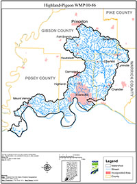
Highland-Pigeon WMP 00-86
Summary
Highland-Pigeon Watershed drains nearly 300,000 acres of southwestern Indiana to the Ohio River. Since settlement by Europeans, the landscape of the watershed has been altered dramatically. Over the decades, settler activities have changed the dynamic equilibrium of the streams and their upslope systems. The cumulative effect of these watershed changes on the aquatic ecosystem has been degradation of water quality, loss of floodplain storage, diminished wildlife populations, and decreased aesthetic and recreational values. This Watershed Management Plan was written to evaluate the severity of these changes and to recommend implementation of best management practices, engineering studies, and educational opportunities to improve water quality in Highland-Pigeon watershed.
Major nonpoint sources of pollutants to the watershed are row crop agriculture, mined lands, and urban runoff. Cropland area in the watershed has been reasonably constant since 1997. Watershed wide, conservation tillage systems were used on 25% of cropland in 1997, 16% of cropland in 1998, and 33% of cropland in 2000. Data on the conservation tillage in the watersheds are insufficient to statistically demonstrate trends. In the year 2000, the Warrick County portion of the plan area had the highest rate of conservation tillage adoption, with 51% of its cropland in some type of conservation tillage.
While all 37 subwatersheds are impaired for aquatic life support to some degree, among the healthier subwatersheds, and those most warranting protection against degradation, include principally Smith Fork (subwatersheds 20 and 21), Little Pigeon Creek (subwatershed 12) and Big Creek (subwatersheds 17, 18 and 19).
There are also extensive bottomland wetlands along Pigeon Creek and the Ohio River (subwatersheds 15,19,21 and 33) that remain. We recommend these be studied for enhanced legal protection, perhaps in association with an overall corridor initiative for the watershed.
The information, data and recommendations found within this document draw heavily from “Pigeon Creek Watershed Diagnostic Study” written by Harza Engineering Company, October 2000, commissioned by Evansville Water & Sewer Utility(EWSU) and Four Rivers RC&D Area, Inc., and paid for by EWSU and grants from In. Dept. of Environmental Management and In. Dept. of Natural Resources Lake & River Enhancement.

