Summary
The United States has more than 3.5 million miles (56 million kilometers) of rivers and streams that, along with closely associated flood plain and upland areas, comprise corridors of great social, cultural, and environmental value. Increases in human population and industrial, commercial, and residential development place heavy demands on wetlands, streams, rivers, and lakes. These demands result in degradation of water quality, loss of habitat for fish and wildlife, and decreased recreational and aesthetic value. Coastal areas are especially vulnerable to development pressure and are currently ten times as densely populated as inland areas (Lake Michigan Coastal Program.
Northwestern Indiana’s Lake Michigan watershed is one of the most industrialized and populated areas in the state, and Porter County’s population is projected to increase by 12% by 2030. In recent years local, state, and federal agencies, as well as many private organizations and individuals, have focused effort on restoring water quality, floodwater storage functions, biological integrity, and recreational benefits to rivers and streams within the Calumet Region, including Salt Creek.
These efforts include work completed by municipalities within the watershed, local governments, Indiana Department of Environmental Management (IDEM), Indiana Department of Natural Resources (IDNR), the National Park Service- Indiana Dunes National Lakeshore (INDU), Northwest Indiana Steelheaders, Northwestern Indiana Regional Planning Commission (NIRPC), Save the Dunes Council and Conservation Fund, Soil and Water Conservation Districts (SWCDs), United States Fish and Wildlife Service (USFWS), United States Geological Service (USGS), United States Army Corps of Engineers (USACE), and many others.
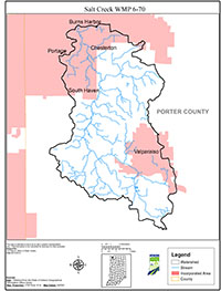
Watershed management is an effective way to cross traditional boundaries and bring people in region together to effectively manage land, increase public understanding and awareness about water quality issues, and promote better stewardship of private and public land. The Salt Creek Watershed Management Plan (WMP) is the framework for the restoration and management efforts within the Salt Creek watershed and is consistent with other efforts underway in the Calumet Region. This plan builds on work that has already been done by the entities acknowledged above and others. It furthers the efforts by identifying priorities and management needs.
In 2006 Save the Dunes Conservation Fund (SDCF) was contracted by IDEM to develop a WMP to address the nonpoint source pollution problem in Salt Creek. SDCF coordinated the development of the WMP, which addresses the nonpoint sources identified in the TMDL, concerns raised by the public and Salt Creek Committee Members, and other problems identified by water quality data acquired during the planning process. Development of the WMP was a community driven process and involved a diverse group of local citizens, experts, organizations, and community leaders.
The WMP documented current water quality and biological integrity and making recommendations for improving water quality. It also includes recommendations for point sources from the TMDL. In addition to covering pollution prevention and remediation, the recommendations include implementation and restoration activities. This plan addresses the improvement of water quality in Salt Creek and its tributaries and is the framework to achieve the plan’s vision.
To reduce the identified stressors in the Salt Creek watershed and address other concerns identified by the Salt Creek Committee Members and stakeholders, the group developed goals. The WMP also identifies activities, responsibilities, partners, potential funding sources, and general timeframes for meeting these goals. Specific implementation plans will be developed as implementation funding is available.

