Summary
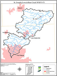
This is a watershed management plan (WMP) for two subwatersheds of the St. Joseph River – the Lower St. Joseph (Allen County), hydrologic unit code (HUC) 4100003100 and Bear Creek (Indiana) HUC 4100003070. The land of these watersheds lies in two Indiana counties, Allen and DeKalb.
The Lower St. Joseph subwatershed lies in Allen County and is predominantly urban and suburban development, encompassing a large portion of central and northern Fort Wayne north of the confluence of the three rivers at city center. There are limited rural residential and agricultural lands in the subwatershed, but these are being developed at a rapid rate.
The Bear Creek subwatershed is named for the Bear Creek, a smallish stream segment that includes flow from the Hursey Ditch system and joins the main stem of the St. Joseph River just upstream of the town of St. Joe, Indiana. The Bear Creek subwatershed includes the city of Leo-Cedarville and the town of Grabill in Allen County as well as the towns of St. Joe and Spencerville in DeKalb County. The Bear Creek subwatershed is predominantly rural and agricultural.
Together with the Lower and Upper Cedar, these two subwatersheds lie directly upstream of the City of Fort Wayne. They have the greatest impact on the quality of Fort Wayne’s source water, both by virtue of their proximity to the city and by the volume of water carried by the streams and the lower portion of the St. Joseph River. The city’s water intake is located within the Lower St. Joseph subwatershed at the St. Joseph River Dam near Johnny Appleseed Park in north-central Fort Wayne. The city’s two supply reservoirs, the Cedarville Reservoir and Hurshtown Reservoir, lie within the boundaries of the Bear Creek subwatershed.
The decision to work on this WMP was made in part to complete planning for the lower section of the St. Joseph River. We also recognized the need for watershed management to complement local comprehensive planning that was being done in Allen and DeKalb counties. The increasing urbanization of northern Fort Wayne and Allen County, including areas around Leo-Cedarville and the two reservoirs, also makes the development of this plan timely.
Water quality monitoring by the City of Fort Wayne and the St. Joseph River Watershed Initiative historically has indicated that these subwatersheds exhibit some of the same problems found in the St. Joseph as a whole: noncompliance with the water quality standard for E. coli for full-body contact, spikes in pesticides found particularly during the spring planting season, and impairment of habitat due to sedimentation and total suspended solids in the water column.
One of our main goals in this planning effort has been to identify critical areas of concern in these two subwatersheds, and to develop a ranking plan to guide us in working to restore and protect these areas. This has been done with the assistance of the City of Fort Wayne and various departments of government in Allen and DeKalb Counties. The Soil and Water Conservations Districts (SWCD), the Natural Resources Conservation Service (NRCS), and the Departments of Health in the two counties have also been of great assistance.
Another goal has been to produce and distribute information for urban dwellers that will help them identify conservation problems in the urban core. Additionally, we have sought to provide information to those people who are moving from the city into exurban or rural areas, those who are facing landowner issues such as wells, septic systems, agricultural implement traffic, odors, and transportation issues that they may not have encountered in the city. As the small communities outside Fort Wayne grow and expand, the impact of construction activities and loss of green space continue to increase.
Public meetings with stakeholders of these two subwatersheds identified the following concerns:
- water quality;
- recreation and access to the water;
- natural area/river corridor preservation and maintenance; and,
- education on watersheds and water quality issues.
Stakeholder involvement has contributed to the identification of problems as well as the choice of goal and work plans for this document. Quarterly meetings and newsletters expedited the flow of information and ideas. As this document is a work in progress, we expect to continue to receive input from stakeholders and to update our progress on the plan every three to five years.

