Summary
The St. Joseph River Watershed Initiative began writing the St. Joseph River WMP in 1999 for the entire sub-basin hydrologic unit area, 04100003. The Initiative has been able to cross political boundaries and engage all stakeholders in the watershed using the watershed approach to water quality as the only way to have a long term positive impact on the quality of the river systems. However, since this WMP covers such a large area it was important to hone in on specific areas of concern in each of the watersheds located within HUC 04100003. One of the initial plan’s goals is to organize stakeholders and produce watershed plans for the watersheds which have not been completed by 2020. To date the Lower St. Joseph River WMP and the Cedar Creek WMP have been completed with 5 watersheds remaining.
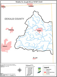
After review of existing data of the remaining areas, findings showed that water quality data for the Middle St. Joseph River watershed did not meet water quality standards at a higher frequency than the remaining four subwatersheds. Another study of riparian buffers and land use throughout the greater St. Joseph River watershed showed that the Middle St. Joseph watershed scored the lowest for wildlife habitat and had the highest concentration of animal feeding operations. Therefore, the Middle St. Joseph River watershed (HUC 0410000305) was chosen as the next watershed to focus efforts. In September, 2009 the Initiative applied for a Clean Water Act 319 grant administered by the IDEM to fund the Middle St. Joseph River Watershed (MSJRW) project. The grant was awarded to the Initiative and the project began in September, 2010.

