Summary
Christopher B. Burke Engineering, Inc. (CBBEL) was retained by the Hamilton County Drainage Board to assist the Hamilton County Surveyor’s Office with leading the investigation, development, and drafting of a Watershed Management Plan (WMP) for the Stony Creek Watershed. Interest in developing the WMP stems from both water quality and water quantity issues associated with the watershed. It is hoped that, through the implementation of this WMP, improved water quality conditions will be realized that will benefit all residents of the Stony Creek Watershed.
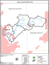
The Stony Creek Watershed drains portions of east-central Hamilton and west-central Madison Counties and is a tributary to the West Fork of the White River, with the confluence in the City of Noblesville, Indiana. The Stony Creek Watershed covers approximately 57 square miles, or 36, 539 acres of primarily agricultural lands.

