Summary
In 2002 the Tippecanoe Environmental Lake and Watershed Foundation (TELWF) along with JF New & Associates worked to complete a draft Watershed Management Plan (WMP) for the Upper Tippecanoe River watershed. The WMP was funded by the Indiana Department of Environmental Management’s (IDEM) 319 Program. Upon completion of the draft WMP IDEM’s requirements for such a plan expanded. In effort to meet the new expanded checklist (2003), TELWF hired a watershed coordinator to facilitate and document on-going activities in the watershed and supply updated information to relevant chapters as required by the checklist. Sections of this final WMP were drafted with the assistance of staff at Williams Creek Consulting, Inc. and Commonwealth Bio-monitoring, Inc.
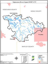
The Upper Tippecanoe River Watershed (Hydrologic Unit Code (HUC) 05120106010) is located northeast of Warsaw in portions of Kosciusko, Noble, and Whitley Counties, Indiana. The watershed drains approximately 72,846 acres (113.8 square miles) and encompasses eight U.S. Geological Survey fourteen-digit watersheds. The Upper Tippecanoe River Watershed is part of the larger Tippecanoe River Watershed (HUC 05120106). Water from the Tippecanoe River discharges into the Wabash River northeast of Lafayette, Indiana eventually converging with the Ohio River in southwestern Indiana.

