Indiana Erosion Along Lake Michigan
Indiana Lakeshore Erosion

The environmental changes in Lake Michigan water levels have impacted the Indiana shoreline for decades.
The lake levels fluctuate greatly, peaking at near-record levels in late 2019 at more than 582 feet. This level is predicted to hold steady through June 2020, although as recently as 2013 the lake level stood at near record lows of 576 feet. The cyclical nature of these changes makes it difficult to prepare for the extent of natural erosion that may occur along the 45-mile stretch of Indiana shoreline in three counties (Lake, LaPorte, Porter). Coastal erosion can be significantly increased when there are barriers to the natural sediment drift along the shore. Human activities such as development, construction of shoreline protection and recreational activities can influence natural coastal processes.
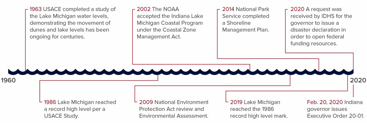
Efforts to protect the Indiana coastal regions date back as early as 1963, when the U.S. Army Corps of Engineers started the first of many environmental studies in the area. The federal government also owns a portion of the shoreline—resulting in a shared responsibility between local, state and federal entities. Several efforts, such as the importing of massive amounts of sand, as well as the construction of shoreline barriers and seawalls have slowed the natural but damaging effects of the lake changes.
Surrounding states have sought federal assistance due to singular events (specific time frames) that have met FEMA damage thresholds. In Indiana, the damage has occurred over time and not been restricted to a single event: a requirement for a state and federal disaster declaration and availability of the State Disaster Relief Fund and federal funds.
In February 2020, Governor Eric Holcomb issued Executive Order 20-01 directing state agencies to collaborate, assess continued impacts and plan for additional solutions.
View the Indiana Coastal Atlas
Lake Michigan Shoreline Timeline
Shoreline Photos
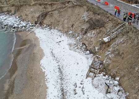
Beverly Shores, January 2020 (Photo credit: IDHS)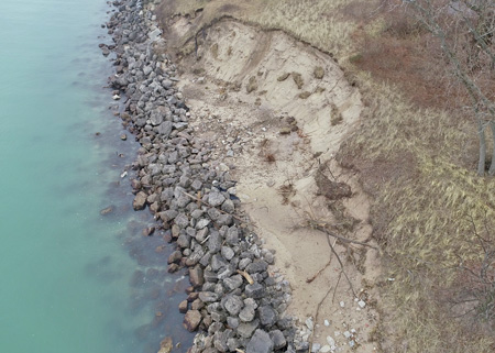
Beverly Shores, January 2020 (Photo credit: IDHS)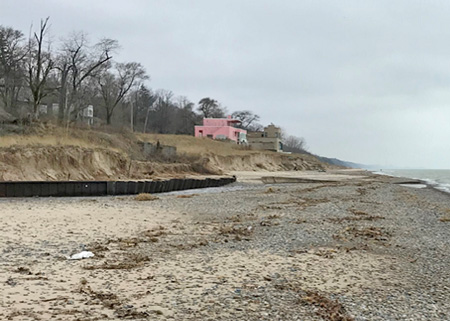
Beverly Shores, January 2020 (Photo credit: IDHS)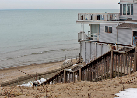
Long Beach, February 2020 (Photo credit: IDHS)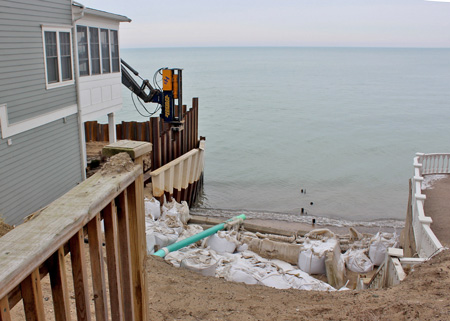
Long Beach, February 2020 (Photo credit: IDHS)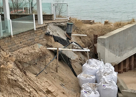
Long Beach, February 2020 (Photo credit: IDHS)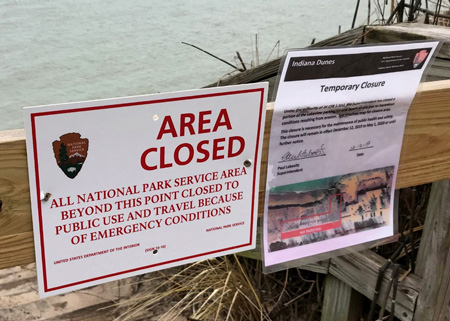
Indiana Dunes National Park, January 2020 (Photo credit: IDHS)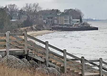
Ogden Dunes, February 2020 (Photo credit: IDHS)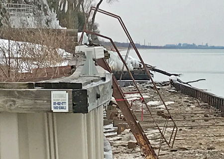
Ogden Dunes, February 2020 (Photo credit: IDHS)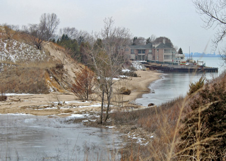
Portage Park, February 2020 (Photo credit: IDHS)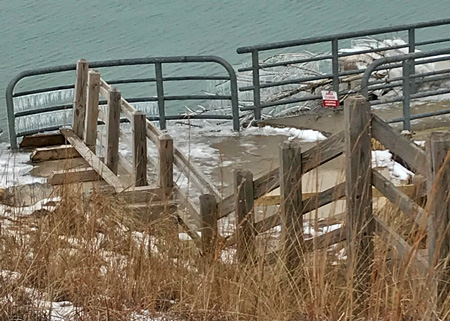
Portage Park, February 2020 (Photo credit: IDHS)
Latest News
Frequently Asked Questions
- FAQs
- Why is the Lake Michigan shoreline eroding?
The U.S. Army Corps of Engineers reports Lake Michigan’s water level cycle is reaching record high levels. The higher lake levels are causing higher storm surge activity, which is causing more destructive wave action to pull the sands away from the beaches and associated dunes. Additionally, a pattern of warmer winters has prevented normal shore ice protection forming that protects sand from being pulled away.
- Does the size of the Lake Michigan shoreline and beach change when the water levels change?
Yes. In general terms, the Lake Michigan shoreline and beach “inflates” or gets wider as sand is deposited and dunes form during periods of lower lake levels, such as experienced in 2013. As the lake level rises, the sand beach, dunes and shoreline typically becomes narrower as erosion occurs and the ground is inundated. Large storm events — that can occur during both periods of low or high water — can lead to significant erosion of the beach and shoreline. These events typically occur during the fall and winter months.
- My home is near the shoreline. Will I receive money for any damage that will happen to my property?
Although flood-related erosion may be covered by flood insurance, it is not covered by the National Flood Insurance Program (NFIP). When purchasing private flood insurance, check with your agent regarding the coverage for loss of land. NFIP flood insurance is designed to provide coverage to buildings and their contents and therefore does not cover the loss of land. Damage caused by earth movement even when flooding directly causes the earth movement is not covered. Examples of earth movement which are specifically excluded from a NFIP policy include land subsidence, sinkholes, destabilization or movement of land that results from accumulation of water in subsurface land area, or gradual erosion. Following a disaster, the Federal Emergency Management Agency (FEMA) and the state will collaborate on a preliminary damage assessment by defining the incident and period when damage was sustained. FEMA does not consider seasons, cyclical conditions or multiple events over an extended time period as disaster damage.
- What is the difference between a flooding event and shoreline erosion?
The Federal Emergency Management Agency (FEMA) defines erosion as a “process of the gradual wearing away of land masses,” while flooding is defined as “a general and temporary condition of partial or complete inundation of normally dry land areas.”
- What is the state doing to address the shoreline erosion?
The Indiana Department of Natural Resources (DNR) is the lead state agency on all erosion and waterway issues.
DNR oversees several permits related to Indiana bodies of water. The Lake Michigan Coastal Program (LMCP) supports coordination and partnerships among local, state, and federal agencies and local organizations for the protection and sustainable use of natural and cultural resources in the Lake Michigan region. Find more information about DNR permits below.
The Indiana Department of Environmental Management (IDEM) regulates activities in lakes, rivers, streams and wetlands to ensure that those activities maintain the chemical, physical and biological integrity of these waters. This is done through Section 401 Water Quality Certifications. These certifications are issued in partnership with the Army Corps of Engineers’ Section 404 Dredge and Fill Permits. An IDEM stormwater permit may also be required for work near bodies of water. For more information on permits through IDEM, call 1-800-451-6027.
The Indiana Department of Homeland Security (IDHS) collects damage assessments following a natural disaster as well as evaluates and collaborates mitigation efforts across all 92 counties. IDHS is the primary conduit to FEMA following a natural disaster and coordinates all federal disaster and mitigation funding for Indiana. Under the authority of the Office of the Indiana Governor, IDHS manages the State Disaster Relief Fund, a safety fund designed to help individuals and entities recover following a disaster.
- What is the disaster declaration process?
Disaster declarations through the federal Stafford Act must meet specific criteria. For a natural catastrophe (such as hurricane, tornado, storm, etc.) there must be a defined date range during which the incident occurred. FEMA grant funding for emergency protective measures or disaster-related damage to public infrastructure and homes is only made available through a presidential declaration, when a disaster exceeds state and local recovery capabilities. A state disaster declaration does not guarantee federal funds.
Sequence of Events for a Disaster Declaration
When a weather or other severe incident occurs, the following steps are followed:
- Local emergency and public works personnel, volunteers, humanitarian organizations and other private interest groups provide emergency assistance required to meet immediate human needs and restore essential services vital to public health and safety.
- At the same time, preliminary damage and impact information is gathered by local government and emergency officials and conveyed to the Indiana Department of Homeland Security (IDHS).
- If necessary, the governor declares a state of emergency and invokes the state's emergency plan to augment individual and public needs as required, including the use of all state agencies’ resources and the National Guard's military resources.
- When the state determines that the recovery appears to be beyond these combined resources, a request for FEMA to conduct a preliminary damage assessment is made.
- FEMA personnel from the appropriate regional office are deployed and join state and local representatives to conduct joint damage assessments and submit the results to the governor's office.
- If the state judges that this survey data indicates full recovery is beyond available local and state capabilities, the governor submits a written request to the president through FEMA's regional office asking that federal aid be provided under a major disaster or emergency declaration.
- Following a FEMA regional and national office review of the request and findings of the joint damage survey, the FEMA director provides the president with an analysis of the disaster conditions and a recommended course of action.
- From this information, the president declares that a major disaster or emergency exists in the state, or FEMA advises the governor of a denial of the request.
- What is the difference between "natural erosion" and "accelerated erosion"?
Shorelines change naturally over time because the shoreline is constantly being bombarded by wave or ice movement. This perpetual motion grinds and displaces soil particles which end up in the lake. In natural conditions this is typically a very slow process over a long period of time. However, human activities have changed the balance which greatly accelerates the natural erosion processes — this is called accelerated erosion.
- Are sandbags an option for shore protection?
Sandbags are not an effective solution for long-term shore protection. Sandbags as shore protection are not a preferred method of protecting against erosion as the bags are temporary, they cannot withstand wave energy or ice movement, the bags break open and become litter that impacts water quality and wildlife on the shoreline and in the lake, and they slump and cannot hold the slope and shoreline erosion continues. There are alternatives — riprap revetments or relocating structures to a safer site.
In addition, using lake bottomlands as a source of sand to fill sandbags also has an adverse impact to the environment and public trust and will likely not be permitted because doing so removes natural sand from the littoral drift process along the water’s edge that provides necessary material for shoreline and beach creation, stabilization, erosion protection and wave energy dispersal.
- Why do Lake Michigan water levels fluctuate?
Indiana's 45-mile portion of the Lake Michigan shoreline is part of a complex and dynamic process of the Great Lakes systems. The wind and waves have acted in concert over thousands of years to shape the southern shores of Lake Michigan and continue to do so today. Lake levels continually fluctuate as the water seeks a balance between water flowing into and out of the lakes. Waves, generated by strong winds, transport sand along the shoreline, maintaining a balance between sand transport and sand deposition. Additionally, human activities along the shore such as development, construction of shoreline protection and recreational activities can also influence natural coastal processes.
Marine forecasters at the National Weather Service office state that waves have been measured up to 23 feet in height.
- Where can I find information about Lake Michigan water levels?
Fluctuations in Great Lakes water levels have occurred continually since the Great Lakes formed at the end of the Ice Age. Lake levels can affect the extent of shoreline erosion and shoreline property damage, riparian interests (beach widths and public access), dredging and shipping (depth of navigation channels), construction of marinas and other water-dependent facilities, drinking water intakes, cooling water intakes for steel mills and electric generating stations, wetland acreage, and coastal flooding. For more information please visit Lake Level Fluctuations.
- What are the record levels for Lake Michigan?
The record high lake level on Lake Michigan was set in October 1986 at 582.35 feet. In July 2019 the lake was measured at 581.92 feet, only 0.43 feet below the 1986 record high.
The record low was set in January 2013 (576.02 feet). The previous record low Lake Michigan water level was set in March 1964 (576.05 feet).
Source: Lake Level Fluctuations
- I want to know more about DNR permits
How do I find the DNR permit application online?
Please visit Regulatory Permit Programs and Related Information and click on "Use a Permit Application Form or File an Application Online." Once you open the permit form, for Lake Michigan, select "IC 14-29-1 Navigable Waterways Act | No Fee."
What kind of information should I submit with a DNR permit application?
If you are planning to construct a new replacement seawall for a failing seawall, please provide the design plans and identify if you are going to remove the failed seawall. In addition, please provide photos of the failing seawall, erosion damage to yards or exposed home foundation. For beach nourishment, please provide the volume of sand you propose to place along the shoreline.
Do I need permits from other local, state or federal agencies for construction activities?
It is recommended that you contact local officials, the U.S. Army Corps of Engineers, the National Park Service and the Indiana Department of Environmental Management (IDEM) to determine if other permits may be required.
When is it determined that an emergency situation exists and an emergency repair may be approved by DNR?
Indiana Administrative Code (312 IAC 6-7-4) authorizes that the Department of Natural Resources may grant a request to approve emergency construction if, without performing the construction, there is an imminent risk of harm to public safety or major damage to property and at least one of the following conditions exist: (1) No erosion protection structure is present at the site. (2) A failure or significant structural deterioration of an existing erosion protection structure has occurred. Examples include the following: (A) Erosion of the lake bottom has occurred adjacent to a sheet steel wall. (B) Stones in a rock revetment have shifted. (3) Major shoreline erosion has occurred. (4) A bluff face is excessively steep and threatens mass slumping. (5) Without the construction, there would be a likelihood of significant harm to the environment or to public health and safety.
- Where can I get more information about Lake Michigan issues in Indiana?
For additional information please visit Lake Michigan (DNR) or contact Steve Davis, Lake Michigan Specialist with the Indiana Department of Natural Resources.
- Why is the Lake Michigan shoreline eroding?
State and Federal Resources
- State Resources
Indiana Department of Natural Resources (DNR)
- Indiana Coastal Atlas
- Lake Michigan Lake Levels: 1996–2020
- Lake Michigan Lake Levels: 1960–2020
- DNR Lake Michigan Coastal Program/Staff
- DNR Lake Michigan Coastal Program Advisory Board
- Lake Michigan Coastal Program Grants
- Grant Fact Sheets
- Development of Lake Michigan (Indiana Geological and Water Survey)
Indiana Department of Homeland Security (IDHS)

