Planning and Assessment Section Staff (select for contacts)
About the Planning and Assessment Section
The Planning and Assessment Section is a comprehensive section that assists the state government, local governments and the private sector plan prepare for and estimate all levels of outcomes for a disaster, natural or manmade.
This section develops, maintains and enhances more than 70 state-level emergency plans and ensures compliance with federal guidelines. This includes overseeing compliance with the National Incident Management System (NIMS). It also works at the local level and provides planning templates, guidance, review and feedback of emergency plans to counties and businesses.
The Planning and Assessment Section also collaborates with other IDHS sections to provide expertise to plans being validated by the Exercise Section, training data to the Training Section from responses collected from local county governments and businesses and more.
Planning and Assessment Section Staff (select for contacts)
State Emergency Operations Plan open for public comment
IDHS is accepting public comments about the recently updated State Emergency Operations Plan (EOP). The EOP provides a statewide framework for the effective coordination of response operations in support of local governments before, during and after large-scale or complex emergencies and disasters. The EOP and the Emergency Support Function annexes have undergone a review in the last year to ensure the framework is up to date in 2025. Now the EOP and the annexes are open for a two-week public comment period. The final date to submit comments is Friday, March 21, 2025.
Upcoming Events and Deadlines
Note: Not all events on the IDHS calendar are organized, hosted or sponsored by IDHS or other state agencies. Some events are included for informational purposes as events that the public or first responders may find beneficial.
The Planning and Assessment Section manages the reporting cycles for several assessments and surveys of emergency management agencies statewide:
| Assessment or Survey | Deadline (Frequency) |
|---|---|
| Hazard Identification and Risk Assessment (HIRA) | January 30 (every three years: 2021-2024-2027) |
| Threat and Hazard Identification Risk Assessment (THIRA) | October 31 (every three years: 2022-2025-2028) |
| Stakeholder Preparedness Review (SPR) | October 31 (annually) |
| Special Event Assessment Rating (SEAR) | August 26 (annually) |
| NIMS Compliance Survey | November 15 (annually) |
| Comprehensive Preparedness Guide (CPG) 101 Compliance Survey | November 15 (annually) |
Resources
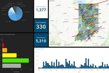
Tornado History Viewer
Tornado History Viewer
The Planning and Assessment Section works with a geospatial information systems (GIS) team that helps develop and maintain systems for agency and public use, such as the Tornado History ViewerTornado History Viewer, which is an interactive dashboard that provides details about the hundreds of verified tornadoes that have occurred in Indiana since 1950. Other projects include: